The Water Security Agency (WSA) recently released the 2017 preliminary outlook for spring runoff.
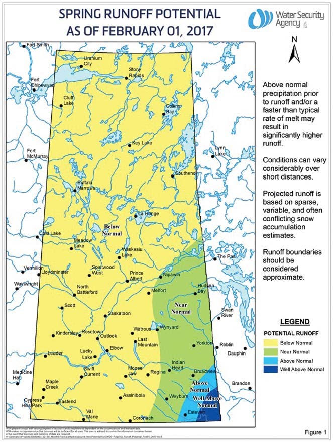
Most of the province received below normal snowfall resulting in a below normal runoff potential across most of Saskatchewan. Many areas saw the snowpack almost completely melt or lost to sublimation in January due to above normal temperatures. This melting of snowpack would have saturated the soil surface, reducing the infiltration capacity available for the melt of any late season snow.
The southeast portion of Saskatchewan is the exception. The snowpack in the southeast is near normal, increasing to well above normal in the very southeast corner. Above normal runoff is expected in the lower Souris River Basin below Rafferty and Alameda Dams, including the Antler River, Gainsborough Creek, and Lightning Creek basins.
This is a preliminary outlook and the snowpack could continue to develop for another 6 to 10 weeks. Also, it is important to note that a majority of the province was wetter than normal going into freeze-up in November of 2016. Higher than normal precipitation going forward and/or a rapid spring melt could significantly increase the runoff potential.
Although the snowpack in most areas is below normal, even a below normal runoff could compound flooding issues in regions with closed basins as many of these areas are at well above normal or record levels following several high runoff years.
The Water Security Agency will be coming out with the 2017 Spring Runoff Forecast in March. For more information on spring runoff or stream flows and lake levels visit www.wsask.ca.