WESTERN PRODUCER — There may be a glimmer of hope this spring for prairie producers who need a break from bone-dry fields and drought-plagued pastures.
Drew Lerner, president and senior agricultural meteorologist with World Weather Inc., said factors are lining up to bring relief to drought-stricken areas this year, although patience will be required.
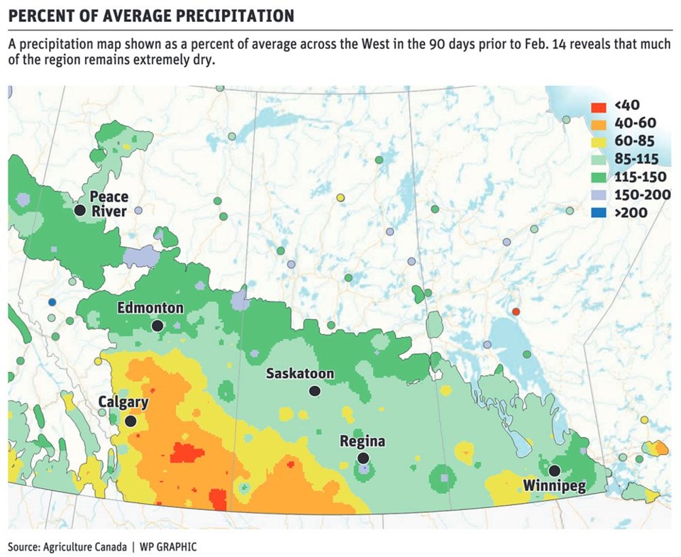
The depth of Western Canada’s soil moisture deficit is still severe in many areas, particularly central and southwestern Saskatchewan and southern Alberta, he said.
Emerging from a multi-year drought cycle will take time but at least there are positive signals of some relief on the horizon.
“We are going to see some improvements… and it looks like we’ll get a good mix of weather across the Prairies as a whole,” Lerner said during a Feb. 16 web presentation hosted by the Saskatchewan Wheat Development Commission (SaskWheat).
“I think there’s going to be a lot of worry as we get into April and we look at the moisture profile in parts of Alberta and Saskatchewan…,” he added.
“There’s still going to be a lot of dryness — a lot of fear and a lot of concern — but I think as soon as we get into the latter part of April and especially May, we’ll start seeing this pattern breaking down and giving way….”
Lerner’s spring forecast suggested a continuation of above-average snowfall for much of Western Canada in March and limited precipitation after spring thaw.
April rainfall amounts will likely be greatest in Manitoba, northeastern Saskatchewan and parts of northwestern Alberta, he said.
Overall, though, March and April will have a limited positive impact on overcoming persistent drought conditions, he added.
Despite above average snowfall in eastern and northern regions of the Prairies, there is still a significant portion of the Canadian Prairies that has little or no snow cover, he said.
Growers in those areas can probably expect to enter the spring seeding season with extremely poor soil moisture conditions.
“There are definitely some pockets out there that aren’t so bad off but there’s also a significant portion of our production area that is hurting for moisture,” Lerner said.
“We’re still going to need good spring precipitation, but most significantly in the central and southwest parts of the Prairies.”
Relief could arrive beginning in May, as long as environmental factors line up.
For starters, the Pacific Decadal Oscillation (PDO) needs to remain in a strong negative phase.
The PDO is a recurring pattern of ocean-atmospheric climate variability associated with warmer-than-average or cooler-than-average surface water temperatures in the Pacific Ocean, north of the 20th parallel.
During a positive PDO phase, the surface temperatures of the Pacific Ocean along the west coast of North America become warmer.
During a negative phase, ocean temperatures are cooler.
A strong negative PDO phase is commonly correlated with above-average precipitation for much of Canada and reduced rainfall in the central U.S. Plains, Lerner said.
Surface temperatures in the Gulf of Alaska and along the Pacific Northwest coastline are currently in a strong negative phase, the strongest weather experts have seen since the late 1950s and early 1960s.
Importantly, annual rainfall amounts in Western Canada during that period were significantly above average, and rainfall in the central U.S. Plains and eastern United States was below average.
If similar conditions play out this year, relief could be on the way for the Canadian Prairies.
What’s more, markets for Canadian commodities could see continued strength, based on the potential for less production in the central United States and ongoing drought concerns in key regions of South America.
While there is evidence that the negative PDO phase is beginning to weaken, it is still likely to remain in place for some time.
“This cool water that’s out there is going to play a huge role in U.S. weather as well as a smaller role on the (Canadian) Prairies,” Lerner said.
The negative PDO phase may be weakening, “but as long as it doesn’t completely go away, I think we’ve got a lot of support for potential of dryness in the United States and rain across the (Canadian) Prairies.”
Lerner cautioned, however, that other environmental factors must also fall into place.
For example, a continuation of La Nina will be supportive for increased precipitation on the Canadian West, as will the development of a persistent high-pressure ridge over the central U.S. this summer.
“If we can do that, the Canadian Prairies are going to be all right,” despite a dry start in some regions, Lerner said.
For Canadian producers, the strong negative PDO is “really a pretty encouraging pattern.”