YORKTON, CANORA, KAMSACK, PREECEVILLE, CARROT RIVER — A proposal to change the boundaries of Saskatchewan's 14 federal electoral districts would see the riding of Yorkton—Melville grow larger geographically.
Every decade, after a census, the boundaries of electoral districts are redrawn nationwide to account for changes in population. The task for the Federal Electoral Boundaries Commission for Saskatchewan is to divide the province into 14 seats that are as equal in population as possible while still taking geography into account.
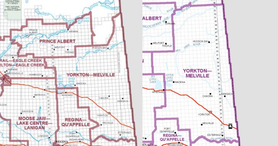
The current Yorkton—Melville goes as far as Mistatim in the north, St. Brieux in the west, the Manitoba border in the east and Esterhazy in the south. It has a population of 71,220 and is 41,801 square kilometres.
The commission's proposal would see the addition of Carrot River and Red Earth in the north, and Punnichy and Ituna in the southwest. Watson and Quill Lake in the west would be removed. The result is a riding with a population of 78,865 and is 56,148 square kilometres.
"The Saskatchewan commission is pleased to present its proposal for public comment," said Georgina Jackson, chair of the three-member commission. "We look forward to hearing everyone's views during the public consultation of our work."
A hearing for public feedback will be held at Yorkton's Ukrainian Cultural Centre on Monday, July 11 from 10:30 a.m. to 5 p.m. Those wishing to make a presentation should give notice to the commission before Monday, June 13. Comments about the proposal can also be emailed or mailed to the commission without having to make a presentation.
After the commission holds the hearings, a final electoral district boundary map will be drawn.
If the province was divided by 14 seats strictly based on population, each seat would have 80,893 people. In the proposal, the smallest seat in population would be Desnethé—Missinippi—Churchill River, which would have 45,524 people, but geographically contain the northern half of the province. The largest seat would be Saskatoon Centre, which would have 89,092 people. Geographically, that riding would contain all of Saskatoon within Circle Drive, with the exception of a chunk in the northeast bordered by College Drive and the South Saskatchewan River.
