REGINA — The Water Security Agency (WSA) has issued the Spring Runoff Forecast for 2024.
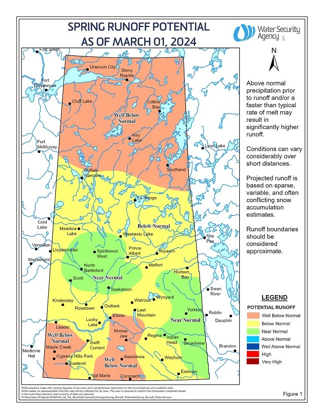
A near normal runoff is expected in the Saskatoon area and west toward Biggar, as well as in the eastern portions of the grain belt along the Manitoba border. The remainder of the province is expected to experience below to well below normal runoff this spring.
As of March 4, snowpack generally ranges from below to well-below normal across the province. Recent snowstorms in early March brought up to 40 cm of snow to much of southern and central Saskatchewan, which has improved runoff potential for the province.
This runoff forecast report updates the preliminary report issued in February 2024, with the inclusion of data from snowpack surveys.
Over the winter, WSA took action with conservative operating plans focused on retaining water supplies that has helped keep water levels at most major reservoirs at or above normal levels for this time of year.
In some southern areas, including the Big Stick and the south-central area of the province, persistent drier than normal conditions may lead to drier than normal conditions and localized water supply shortages this spring.
The spring runoff is dependent on fall soil moisture, snowpack water content, and how quickly the snowpack melts.
Although drier conditions persist, most major water supply reservoirs in southern Saskatchewan are at or above normal levels; however, reservoirs such as Avonlea and some in the southwest (e.g., Altawan and Cypress) may experience surface water supply concerns due to the depleted snowpack.


