Here are updated weather warnings in effect from Environment Canada.
9:02 PM CST Monday 13 June 2022
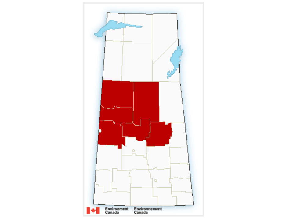
Rainfall warning in effect for:
- R.M. of Battle River including Sweet Grass Res. and Delmas
- R.M. of Britannia including Hillmond
- R.M. of Buffalo including Wilkie and Phippen
- R.M. of Cut Knife including Cut Knife
- R.M. of Eldon including Maidstone and Waseca
- R.M. of Frenchman Butte including St. Walburg
- R.M. of Glenside north of Biggar
- R.M. of Mayfield including Maymont Denholm and Fielding
- R.M. of Meota including Meota and The Battlefords Prov. Park
- R.M. of Mervin including Turtleford Mervin and Spruce Lake
- R.M. of North Battleford northwest of The Battlefords
- R.M. of Paynton including Paynton
- R.M. of Turtle River including Edam and Vawn
- R.M. of Wilton including Lashburn Marshall and Lone Rock
Rainfall warning in effect for:
- Green Lake
- R.M. of Beaver River including Pierceland and Goodsoil
- R.M. of Big River including Big River and Chitek Lake
- R.M. of Loon Lake including Loon Lake and Makwa
- R.M. of Meadow Lake including Waterhen Res.
Rainfall warning in effect for:
- Candle Lake Prov. Park and Narrow Hills Prov. Park
- Hwy 165 between hwys 2 and 914 including Pinehouse Lake
- Lac la Ronge Prov. Park including La Ronge
- Montreal Lake and Molanosa
- Prince Albert Nat. Park
Rainfall warning in effect for:
- City of Prince Albert
- District of Lakeland including Emma Lake and Anglin Lake
- R.M. of Birch Hills including Muskoday Res.
- R.M. of Buckland including Wahpeton Res. and Spruce Home
- R.M. of Canwood including Debden and Big River Res.
- R.M. of Duck Lake including Duck Lake and Beardy's Res.
- R.M. of Garden River including Meath Park and Albertville
- R.M. of Leask including Leask Mistawasis Res. and Parkside
- R.M. of Meeting Lake
- R.M. of Paddockwood including Candle Lake and Paddockwood
- R.M. of Prince Albert including Davis
- R.M. of Shellbrook including Sturgeon Lake Res.
- R.M. of Spiritwood including Spiritwood and Leoville
- R.M. of St Louis including One Arrow Res. and Domremy
Rainfall warning in effect for:
- R.M. of Arborfield including Arborfield and Zenon Park
- R.M. of Barrier Valley including Archerwill and McKague
- R.M. of Bjorkdale including Greenwater Lake Prov. Park
- R.M. of Connaught including Ridgedale and New Osgoode
- R.M. of Flett's Springs including Beatty Ethelton and Pathlow
- R.M. of Invergordon including Yellow Creek and Tarnopol
- R.M. of Kinistino including Kinistino and James Smith Res.
- R.M. of Lake Lenore including St. Brieux
- R.M. of Moose Range including Carrot River and Tobin Lake
- R.M. of Nipawin including Nipawin Aylsham and Pontrilas
- R.M. of Pleasantdale including Naicam and Pleasantdale
- R.M. of Star City including Melfort and Star City
- R.M. of Three Lakes including Middle Lake and St Benedict
- R.M. of Tisdale including Tisdale Eldersley and Sylvania
- R.M. of Torch River including Choiceland and White Fox
- R.M. of Willow Creek including Gronlid and Fairy Glen
Rainfall warning in effect for:
- Buffalo Narrows and Peter Pond Lake
- Île à la Crosse and Beauval
Rain, at times heavy, is expected.
A significant rainfall event is expected with 50 to 70 mm of rain expected by Wednesday evening.
Heavy rain will begin Tuesday morning and persist through the day on Wednesday, before tapering off Wednesday night.
Heavy downpours can cause flash floods and water pooling on roads. Localized flooding in low-lying areas is possible. Watch for possible washouts near rivers, creeks and culverts.
Severe Thunderstorm Watches have been lifted for:
Regina
Assiniboia-Gravelbourg-Coronach
Estevan-Weyburn-Radville-Milestone
Fort Qu'Appelle-Indian Head-Lumsden-Pilot Butte

