SASKATOON — Saskatoon is fondly referred to as the City of Bridges, finding beauty in every crossing over the South Saskatchewan River.
The city’s very first bridge, the Traffic Bridge, opened in 1907 and was crucial in uniting Saskatoon’s separate communities. Built for both vehicle and pedestrian traffic, it played a key role in the agreement to unite Saskatoon, Nutana and Riversdale.
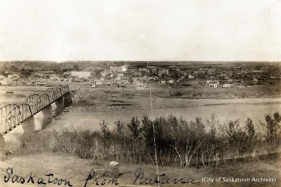
Prior to construction of the city’s first bridge, people crossed the river by ferry or on foot using a railway bridge, circa 1890, at the location of the current Senator Sid Buckwold Bridge. Pedestrian crossings were risky, as there was no separate walkway, meaning people walked directly on the tracks, hoping no train came through.
The Traffic Bridge was closed in 2010 after safety concerns were discovered, and the structure was replaced by a new steel truss aqueduct in 2018. This iconic bridge served as a catalyst for the formation of the city we know today.
The Traffic Bridge is also the site of Saskatoon’s only maritime disaster. In 1908, the S.S. City of Medicine Hat steamship crashed into one of its concrete piers and sank.
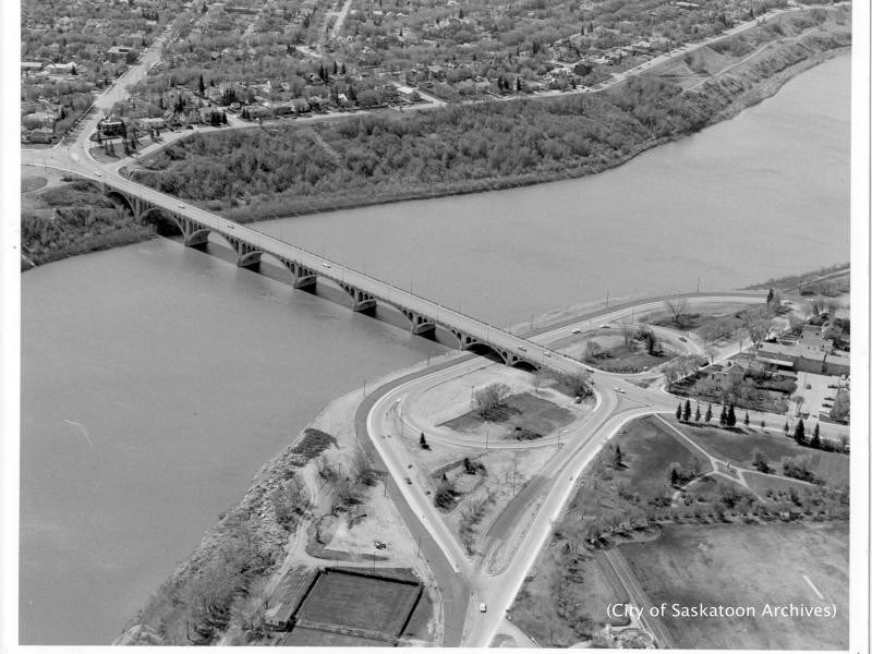
The University Bridge, opened in 1916, is another notable and recognizable city crossing, with its own unique history and significance. The bridge was built to connect the University of Saskatchewan to Sutherland and the rest of the city. Its series of arches decrease in size, designed to resemble a stone skipping across the water.
This crossing, connecting 25th Street to College Drive, was long known as the 25th Street Bridge until it was officially renamed the University Bridge in 2006. By the 1960s, the bridge had deteriorated so badly that city council voted to demolish it, but the cost of replacement exceeded repairs, saving it from demolition.
The University Bridge was originally built with streetcar rail tracks, but they were never used and were removed in the 1940s.
Broadway Bridge is another historically significant crossing, opened in 1932 as a make-work project during the Great Depression. It is the steepest bridge in Saskatoon, with a grade of four per cent. Construction work was done largely by hand to employ as many people as possible, with 1,593 family men working around the clock.
In 2025, Broadway Bridge is closed for reconstruction, expected to reopen in October, forcing commuters and residents to take alternate routes into the Broadway District.
Other Saskatoon water crossing structures
Other river crossings include the Senator Sid Buckwold Bridge, both Circle Drive Bridges, Gordie Howe Bridge and the CPR Train Bridge.
Originally named the Idylwyld Freeway, the Buckwold Bridge was renamed in 2001 to honour the mayor of Saskatoon at the time of its construction in 1966, Senator Sidney L. Buckwold. It is located at the narrowest point of the South Saskatchewan River within the city and is only 183 metres long.
The City of Saskatoon affirms that its bridges are a vital part of the community’s fabric and history. The building of each bridge reflects Saskatoon’s growth, and today, they continue to move people, traffic and the economy forward.
The city’s bridge and structure inventory has an estimated replacement value of about $916 million. The city maintains 80 bridges and structures, consisting of:
-
Eight bridges (the Traffic Bridge and Chief Mistawasis Bridge, opened in 2018, are maintained by Graham Commuter Partners)
-
49 overpasses
-
24 pedestrian crossings
-
28 kilometres of sound attenuation walls
The Bridges and Structures Preservation Program ensures all bridges and structures remain safe and structurally sound. The program includes safety inspections, consultant bridge inspections, washing and sealing deck testing, minor maintenance, major rehabilitations, and maintenance of load ratings.
Railway bridges
The Canadian National Railway Bridge and the Canadian Pacific Railway Bridge are not maintained by the city but are important to its history.
The CPR Bridge, a high steel trestle bridge, opened on June 15, 1908. It is part of the Canadian Pacific Railway trunk line between Winnipeg and Edmonton, the second major rail line routed through Saskatoon. Located on what was then the north edge of the city, it linked the CPR's divisional yards at Sutherland with its downtown station. It replaced a temporary wooden trestle built one year earlier.
A pedestrian walkway was added in 1909. The City of Saskatoon originally requested the bridge be designed to allow a single lane of traffic on each side, but the extra $50,000 cost led to the decision to build the University Bridge instead. The CPR Bridge is 341 metres (1,120 feet) long.
More information on Saskatoon’s bridges is available on the Discover Saskatoon and City of Saskatoon websites.
Circle Drive Bridges
The first Circle Drive Bridge, opened in 1983, connected northern neighbourhoods with the south and east, eliminating the need to drive through downtown.
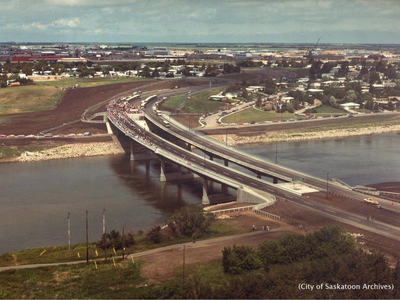
A central pedestrian walkway was added in 2007 during an expansion project that included two more traffic lanes.
The Circle Drive South Bridge, opened in 2013, was renamed Gordie Howe Bridge in 2016 after the local hockey legend’s death. Its completion fulfilled the vision of a complete Circle Drive freeway, first drawn on a 1913 “Plan of Greater Saskatoon” map.
The city’s most recent bridge, the Chief Mistawasis Bridge, opened in 2018, connecting the north industrial area with eastern neighbourhoods. It is named for Chief Mistawasis, head of the Prairie Tribe and a signatory of Treaty 6 in 1876. Previously referred to as the North Commuter Parkway Bridge, the official name was revealed at the 2018 National Indigenous Peoples Day event.
The Meewasin Trail system connects all the city’s bridges, offering many vantage points to enjoy their architecture.

The River Landing area incorporates bridge views into its riverside design, with options to walk under or view them from multiple angles.
"Bridges are metaphors for everything in life, the bridge is not just about getting back and forth between north and south. The bridge is about connecting our communities," said Jim West.


