The Saskatchewan Watershed Authority is predicting higher than average run-off for the Weyburn area this spring, but the City and RM say they are well prepared.
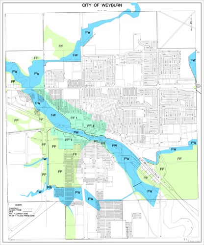
"The City of Weyburn has a dyking system in place," said Director of Engineering Rene Richard. "The dykes are built to a one in 500 flood occurrence. It would have to be something really unbelievable to go over the dykes."
The City of Weyburn has an existing dyke system which is permanent within the flood plain. In the event that water flows in the Souris River rise to a certain level, the City can close off the Government Road and Highway 39 intersection as well as the Third Street and Highway 39 intersection. In order to close off the dyke system, local and highway detours would go into effect.
In fact, the Department of Highways has already put detour signs up along the entrances of Weyburn in the event that the City will have to close off the dykes along Government Road and Third Street. The signs are currently covered but could become ready at a moment's notice.
Richard does not anticipate that the signs will need to be uncovered this spring.
"We are prepared," said Richard. "We have our flood plan and we have our dyking system so we're ready to go."
The Rural Municipality of Weyburn is also prepared, according to Reeve Carmen Sterling. She said that the RM has already begun removing snow from around culverts and keeping them clear for when the water starts to flow.
"In the past we've had to steam culverts open, like the City would do with manholes," said Sterling.
She said that the RM will not know what the impact of this year's snowfall will have until more of it melts, but she said they are already beginning to see signs of spring in the fields.
"A fair bit of snow has melted, there's a lot of stubble showing on the level."
She said that the RM office has not received very many calls to-date about the potential spring run-off but they have made their ratepayers in the flood plain aware of the $22 million in grants available through the province's Emergency Flood Damage Reduction Program and is in contact with the City and Watershed Authority.
"If anyone has seen any signs or has any concerns let us know if you think you're going to have a problem," said Sterling.
Since the announcement of the $22 million Emergency Flood Damage Reduction Program on February 22, the Saskatchewan Watershed Authority has had strong interest in the program. In the southeast region, 21 communities, seven RMs and 16 rural residences are now receiving assistance, according to Clinton Molde, regional manager for the Saskatchewan Watershed Authority.
"The intent of the Emergency Flood Damage Protection Program is to help communities reduce or prevent flooding this spring. Not only communities, but rural municipalities, individual farmers and country residences, as well," said Molde. "We provide technical and financial assistance for homes and other structures."
For most communities, and some more difficult rural situations, the first step is an engineering investigation by a consultant to determine and design the actions necessary to mitigate flooding. The Watershed Authority pays full costs for the engineering work. Once the engineering reports are received, the Authority will sign agreements to cost share the required works with the community or individual.
The Watershed Authority will cover 100 percent of engineering costs, 85 percent of approved construction costs for berms or channels for individuals, 75 percent of approved construction costs for communities, 50 percent of approved short term costs like sand bagging and 100 percent of the cost to test drinking water supplies that may have been contaminated by flood waters.
Molde said that a number of factors have contributed to the high spring run-off potential in the southeast.
"Last year, from April to October, we had 120 millimetres of precipitation above normal," said Molde. "What ended up happening was we went into winter with a surplus of soil moisture. We have a good snowpack out there now and as of March 1 the amount of water in that snowpack is anywhere from 150 to 200 percent above normal."
He said that the Souris River is forecasting a one in 10 year event for peak flow.
"We are estimating a peak flow of 50 cubic metres per second through Weyburn on the Souris," said Molde. "Last year it was a 15-cubic metre peak flow."
Molde said that anyone with concerns about flooding should check the provinces newly launched website, www.saskflood.ca, which provides timely updates on flood events in the province.


