A few years after Confederation, in the 1870s, the Dominion Lands surveys were organized by the Dept of the Interior in Ottawa to open up farming settlement in the West. The men of the surveying parties lived in tents, on the move in fair and inclement weather, through prairie, hill, mountain and bush country. The surveyors would hire guides and hunters from a Native or Métis community — someone familiar with the land and one who could hunt to supplement the party’s dry goods. Each surveyor carried a recording book, in which he wrote details of observations, measurements, and staking. Their extensive findings were compiled in a “physiographic catalogue” of lands for the benefit of the Dominion Government, land agents, and settlers. Included in the narrative were observations of particular landmarks. After pitching their tents, and preparing a meal, the crew crowded by the campfire to visit and talk about their work, discuss the possible use of the land, farming, cattle ranching or both, and no doubt what life was like back home. The survey of the Yorkton region dates back to 1880. Here are excerpts from the register for Township 26, Range 4, West of the 2nd Meridian: “North-undulating prairie, with heavy poplar and willow bluffs. A creek 80 links wide (52.8 feet) crosses the north quarter of Section 36. A.L. Russell, 1880. The west is all good clay loam. The north half is nearly all solid poplar bush in which there is good fencing and some fair building materials. W. Ogilvie 1880.”
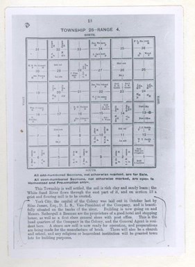
The Toronto headquartered York Farmers’ Colonization Company founders of Yorkton based much of their plans from these physiographic records when they chose the area and organized colonization in 1882. Silas James, Dominion Land Surveyor was also Vice-President of the York Farmers Colonization, and he was the one who surveyed York City in October 1882.
Contact Terri Lefebvre Prince,
Heritage Researcher,
City of Yorkton Archives,
Box 400, 37 Third Avenue North
Yorkton, Sask. S3N 2W3
306-786-1722
[email protected]


