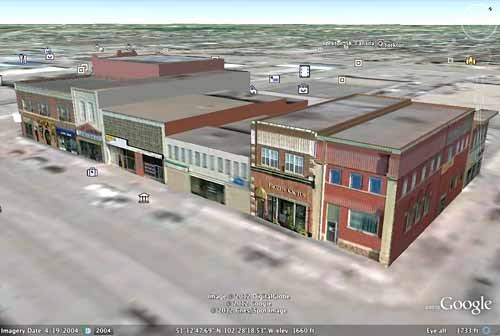
Eight buildings in Yorkton are now viewable as 3D models in Google Earth.
The buildings, a cluster of historic commercial properties on Broadway Avenue, were added to the software in January.
3D building models are a feature of Google Earth, Google's free global mapping application, designed to enhance the virtual exploration of towns and cities. Users of the software can examine the models from all angles at their actual locations on the map.
The models are created by volunteers, who generate them on Google's behalf using maps and photographs as references. The buildings in Yorkton and many other Saskatchewan communities are the work of the Architectural Heritage Society of Saskatchewan (AHSK), which aims to bring the province's heritage buildings to life online through its Model Saskatchewan project.
The Yorkton models were created by Julio Signorelli, a Chilean-born electrical engineering technician who now lives in Ontario.
Signorelli, who has never visited Saskatchewan but says he "will make a point to visit now," has created nearly 3,000 Google Earth models of buildings in Canada and around the world in his spare time.
"I like especially the grain elevators, the churches, and the hotels," says the modeler. "Many of these buildings are being destroyed, and we think this is the best way to keep a record of the time past."
AHSK is seeking local volunteers to model additional significant buildings in Yorkton and other Saskatchewan communities. The models "can help residents and visitors understand your community in a way that maps and photographs can't," suggests Gregg Babish, coordinator of the Model Saskatchewan project.
Other communities in the region with 3D building models on display include Canora, Kamsack, Langenburg, and Melville.
The heritage society's website is www.ahsk.ca.
.png;w=120;h=80;mode=crop)

