Understanding the surveying of lands and the meaning of Townships
By the late 1860s, the Dominion Government and Eastern Canadians saw that the vast western territories of Canada should be opened for agriculture. Already, land was getting scarce in Ontario. By the mid-1870s Canada's North West Territories was the focus of the federal government. Settlement was desired, as it would provide homesteads for the sons and daughters of eastern farmers and to serve the markets of eastern Canada.
First, to secure the land for settlement, the Hudson's Bay Company's hold on the territory had to be terminated, and that came about in 1869 with the surrender of the company's charter. The Imperial Government then transferred all to the Dominion Government. Even as plans were being made for the territory, the government had recognized the Native people's right to title, and Treaties followed.
Yorkton area became part of Treaty No. 4 signed at Fort Qu'Appelle in 1874, where Chiefs of the Saulteaux, Cree and Assiniboine Nations and Dominion Government Officials affixed their signature to the surrender of seventy-five thousand square miles of what is now southern Saskatchewan, small portions of what are now Manitoba and a portion of southern Alberta.
Other events that readied the North West for settlement were the creation of the province of Manitoba in 1870, the Dominion Lands Act of 1872, the creation of the paramilitary force, the North West Mounted Police in 1873, the organization of the Council of the North West Territories in 1873, and the Dominion Land Surveys starting in 1877 in what is now Saskatchewan. One of the major events for the successful opening of the West was the promise by the Dominion Government in 1881 of a transcontinental railway.
Then the surveyors came - the unsung pioneers. There is little written about their work in pioneer stories, except perhaps the mention of the dates of the surveys. They began their work in the 1870s. It was a painstaking work of observations, measurements and staking for the men of these surveying parties living in tents, on the move in fair and inclement weather, through prairie, hill, and bush country. Their extensive findings were compiled in a "physiographic catalogue" of lands for the benefit of the Dominion Government, land agents and settlers.
It was from those surveyors' records that the officials of the Yorkton Farmers Colonization Company, and all others working with the settlement of the West sought information to decide where to start a colony, or where to stake a claim on a free homestead quarter section.
They obviously looked for reports of good soil, looked for waterways and for timber. In 1883, the York Farmers Colonization Company published a booklet about York Colony. They used some of the surveyors' official records to describe the land, or excerpts thereof. Here are the descriptions for each township under the administration of the Company:
Township 22 - Range 2 (South of Yorkton about 20 miles)
The land is somewhat light and a little broken with water. There is considerable wood suitable for fuel fencing and light building. Altogether, this Township is well adapted for small farming, being beautifully diversified with bush and open prairie. The township diagram shows that there are many homesteads still untaken. (1883) The York Colony Trail passes through this township. (This description was penned by the officials of the York Farmers Colonization Company.)
Township 23 Range 2 (South of Yorkton - 14 miles, approx.)
. "prairie land of very good quality, with quite a number of marshes. The south east part has considerable bush; the land is to a great extent first class and well fitted for settlement. The soil is slightly gravelly but not to injure its fertility. In fact, it is well fitted for agricultural purposes." -Signed Surveyor G.B. Bemister D.L.S. Portage La Prairie
Report of the above township under Oath
This Township is pretty well settled - there are some very fine odd sections for sale at low prices - the nucleus of a village - Boakview is on Section 16 where settlers can procure agricultural implements, etc.
Township 27 Range 2
"The soil throughout is rich black sand loam, depth varying from 9 inches undulating or low rolling prairie, interspersed with "Islands." (An island is a small bluff covered with trees) and belts of popular woods. The trees in the bluffs are from 4 to 8 inches in diameter. There is a fine creek of fresh water which flows across the Township from Section 2 to Section 30. The water throughout this township in lakes and creeks is good and sweet. Altogether, it is a first-class Township for agricultural purposes." Signed Robert W. Lendrum, D.L.S. Hawkesbury. (Report of the above township under Oath.)
This is a magnificent township, and is the home of some of our pioneer settlers. Mr. A.E. Boake, formerly of the Township of York, has a fine general store on Section 10, and Wallace post office is to be established on this Section in the midst of this thriving settlement.
Township 25 Range 3
-"Mostly open prairie with some small spring creeks, some dry and green poplar for fuel and fencing purposes. The village of Armstrong is situated on Lake Armstrong, and is on the trail at the S.E. corner of this Township. A petition for a post office at this place is now in the hands of the Post Master General. Mr. James Sharpe, formerly of County Carleton, Ontario, proposes opening a store and stopping house here."
Township 26 Range 3
"This is all rolling prairie, not much marsh or water, except numerous small running creeks with good water. Soil black clay and sandy loam, clay and sand for subsoil; a good deal of limestone gravel. This is the only place I met any muskeg during the survey; all prairie sod very rich and suited for agriculture." Signed D. O. O'Keefe, Surveyor D.L.S.
Report of above Township under Oath.
This Township is well settled and the odd sections lying between the settled farms are very choice - some of these are already sold to first-class Ontario farmers from the County of York. And the balance is now in the market at prices which will be trebled when the Manitoba and North Western Railway approaches.
Gently undulating prairie, without any scrub or wood, with numerous spring creeks, characterizes this Township.
Township 27 Range 3
"This township is remarkable for having deep rich soil. There are a number of untaken homesteads in the northern part which ought to be sharply looked after by the intending settler. The settlers in this, as in other townships, have built some neat houses and stables and have done considerable breaking, Mr. McEachran with a family and four sons, who have seen much of Manitoba and the North West are settled here, and intend running a threshing machine in the fall of 1884. Mr. Robert Jackson, from the Township of Brock, Ontario, and several others from the same place, have settled in the southern part of this township and intend having a blacksmith shop on Section 3.
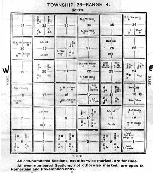
Township 26 Range 4
This Township is well settled, the soil is rich and sandy loam; the White Sand River flows through the east part of it, and on section 13 a grist and flour mill is to be erected.
York City, the capital of the Colony was laid out in October last by Silas James, Esquire, Dominion Land Surveyor, Vice President of the Company, and is beautifully situated on the banks of the river. Building is now going on and Messrs. Neibergall & Reaman are the proprietors of a good hotel and stopping house, as well as a first class general store with post office. This is the headquarters of the Company in the Colony, and the General Agent is resident here. A steam saw mill is now ready for operation, and preparations are being made for the manufacture of brick. There will also be a church and school, and any religious or benevolent institution will be granted town lots for building purposes."
Township 26 Range 5
"This is our most western Township and the homesteads in it are almost entirely untaken. The soil is a rich sandy loam, and the surface is of a rolling nature. A beautiful spring creek runs through the north-eastern part of the Township, having an average width of 25 links and is from 2 ½ to 3 ½ feet deep. There is considerable wood suitable for fuel, fencing and building. Three families of most respectable Scotch farmers have settled here, well equipped with money and implements. Choice odd sections for sale at $8.00 per acre with 7 years credit. Mr. C.J. McFarline and Smith Bros., of Cheshire, England, report this Township as containing magnificent soil and good water."
One surveyor from those mentioned in the above-described surveys is of particular interest to the history of Yorkton:
Silas James, Provincial Land Surveyor for Ontario and Dominion Land Surveyor was born in the Township of York in 1834. His father was born in Ireland in 1801. His mother was born in the Township of York. He married the daughter of Thomas Johnson, a United Empire Loyalist. James came to Toronto in 1854 and studied with a surveying firm for 4 years. He then went to B.C. He returned to Ontario, and was director of Toronto House Building Association. He was also a member of the York Pioneer Society.
Heritage Researcher, City of Yorkton, Box 400
37 Third Avenue North, Yorkton, Sask. S3N 2W3
306-786-1722 [email protected]


