Work has begun on the development of a walking trail in Kamsack that “will help provide young and old with a safe, recreational trail that can be used 12 months of the year in all conditions.”
At its regular meeting on March 28, town council approved in principle the first phase of a proposed walking trail and directed Kev Sumner, Kamsack recreation director, to continue to refine that phase to the next level of detail and investigate costs.
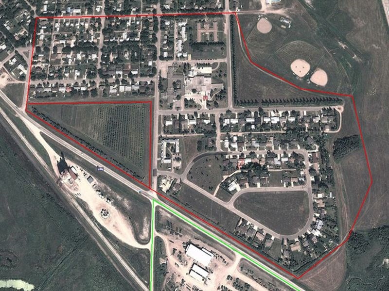
“We have several options, including connecting all corners of the town or just establishing a new trail and then developing more connections from the original,” Sumner told council.
“A walking trail is a great addition to our community’s recreation facilities, a resource that looks good to visitors and potential new residents, and one that our current residents can enjoy at their leisure,” Sumer said. “It will help to promote activity, and fight the health issues that are arising in our population due to inactivity.
“By providing a trail we offer walkers, hikers, cyclists and cross-country skiers the chance to connect to our other recreation facilities in town such as the swimming pool, ball diamonds, soccer fields and our playgrounds.”
The former trail, which had been located next to the creek in the southeast corner of the town, was washed away in large sections because of the spring run-off, he said. Those areas identified as the trail had become almost impassable, especially for those walking with strollers. The creek was partially blocked by beavers to the north and so the decision was to remove the existing benches so they could be used on a new walking trail.
“We’ll get started on the new trails as soon as the ground is dry in the spring,” he said. “We expect the clearing of the new trail to be fairly straightforward, and don’t see reasons for delay, aside from possible weather problems.”
The walking trail could be established in three phases, he said. The first phase would include a link to the Trans-Canada Trail (TCT) that is located in the southeast corner of the town.
“By identifying the TCT with signage, in both directions and towards the town’s amenities, we will be offering residents and visitors the opportunity to use the trail and as custodians we will have an obligation to maintain it.”
The first phase of the Kamsack Walking Trail will be 3.35 kilometres in length, Sumner said, explaining that the first phase of the trail will incorporate the indigenous orchard.
“A loop would be created for those who do not want to complete the 3.35 km of the entire circuit. We would also like to include an interpretive section of each row of the orchard. This will be beneficial to the school groups that do visit the site during the spring and summer.
“Cross-country skiers could also use this loop during the winter because this would be relatively easy to maintain for our public works crew as it would be built into the duties from the first snowfall. A grooming track-setter would be required.
“Continuing on in an anti-clockwise direction, the trail would skirt the back of the houses on Lawrence Road. This area is used by the snowmobilers within the community and could present a possible danger. Signage would be needed in this area alerting all users of the trail of other users. Fortunately there is enough space within the ditch to accommodate all the users of the trail. Snowmobilers would in all likelihood use this part of the trail stretching all the way to the sportsground and swimming pool as traditionally they have used it for many years.
“The walking trail could be directed towards the top of the bank, next to the tree line.
“The sportsground, swimming pool and new medical clinic would be the next area that the trail would reach,” Sumner said. “There is an existing path through this area at the moment so we would just have to make sure it was well identified. This stretch of the trail would need to be plowed throughout the winter so the trails do remain open for the users. With little protection from the elements, we will need to make sure the trails are checked on a weekly basis as drifts can accumulate very quickly.
“By directing the trail closer to the new Assiniboine Valley Medical Centre, rather than towards the airport runway, we are also encouraging more visitors to the clinic to use the trail as well. We will add the swimming pool and medical clinic to the trail signage.
“The trail would then continue on along Miles Street heading west past Eaglestone Lodge towards East Avenue and then onto West Avenue. The trail around this area will need to be maintained with extra vigilance as we would like to encourage as many residents of Eaglestone Lodge as possible to use the trail and swimming pool.
“Finally the first phase of the trail would be complete by connecting Miles Street, West Avenue and the orchard, bringing the 3.35km section to an end.”
Phase 2
Sumner said that for the second phase, two options have been identified; one in which the trail does not cross Queen Elizabeth Boulevard, and one in which it does.
In Option 1 of the second phase, which will be 2.34 km in length, the walking trail does not cross Queen Elizabeth Boulevard because the highway represents a particular risk to users of the trail, he said. It is relatively simple in design but it does include a path that connects from Phase 1 next to the swimming pool and travels behind the Kamsack Comprehensive Institute to the eastern end of Nicholas Street. Users of the Average Joe’s Fitness Centre will have an option to use the path to and from their workouts.
Heading west, the users of the trail would pass all the way to West Avenue where they would head south to the corner of Hawthorn Street, using the school playing field as part of the trail. Then the circuit would be complete by finishing at KCI.
Option 2 of the second phase of the walking trail is, at 3.63 km in length, a little longer than the alternative as it would include the area of the town north of Queen Elizabeth Boulevard next to the new water tower and the children’s playground on Park Street at the junction of Wall Avenue.
As with the first option, the trail would connect with the land behind KCI and the eastern end of Nicholas Street, and the first of two crossings of the boulevard would be next to the historical site of the old water tower. An interpretive sign or marker could be included at this junction which could outline the history of the water tower.
Continuing on, the trail would turn west at the new water tower along Park Street to the playground, then head south towards the boulevard on Wall Avenue, which is recognized as being one of the most picturesque streets in town. The trail would cross the boulevard at the closest crosswalk on Windsor Avenue, and then users would travel southeast along Kendall Street to Nicholas Street where they would head east before heading south on Central Avenue to the Victoria School field and then connect back to the start of the circuit on Dixon Avenue at the swimming pool.
Phase 3
“The final phase of the walking trail would see us connect the Riverside Golf Course in the northwest corner of Kamsack with the first two phases,” he said. This section of the trail would start along Saskatchewan Street until it reached Third Avenue North, and users of the trail have the option to complete a loop that connects Part Street, Fort Pelly Avenue and Saskatchewan Street. If they wanted to continue onto the Riverside Golf Course, the users could head further west then south along Park Street until they reach the junction of the boulevard and the entrance to the golf club road.
There would be an increased risk with the final section of the trail because the construction trucks and semis do use the road as a shortcut.
It is hoped that in 2017 the whole of the Trans Canada Trail (TCT) will be completely connected from coast to coast to coast, he said. “We are very lucky to have the TCT come through our town and by supporting the trail we are emphasizing the benefits of exercise, recognizing Canadian heritage and value a safe, healthy and low cost form of recreation.”
The cost of benches, garbage cans and signage will be researched so they are in place for 2016-17 winter, he said. Reject sand and gravel can be acquired from local sources as needed.
Sumner said that he and the town superintendent will be heading up the project.
“Once the walking trail has been developed, we hope to encourage as many residents and visitors as possible to use the trail and identify any issues that may occur,” he said. Signage will include the town office telephone number so that any problems may be communicated immediately. Each season offers potential issues, including broken tree limbs, winter debris at the start of spring, overgrown grass and weeds, erosion of the trail due to run-off, vandalism and snow-drifts.
“We will also set up a trail volunteers group so that we can encourage them to take pride in the trail when they are using it. This will hopefully lead to a quicker response to any issues that may arise and instil a sense of community pride as well.
“We will also host an annual walk on the trail and invite the residents, schools and community groups to show them that we have this great resource.”
Motorized vehicles would also be one of our biggest concerns as the trail that runs along the orchard and behind Lawrence Road is highly frequented by snowmobilers. Signage will be very specific in what modes of transportation are allowed on the trails, and public awareness will be high on such matters.


