The monthly flood forecast is in and North Battleford and area are now at high risk.
According to the forecast for April from the provincial Water Security Agency, North Battleford is included in the area that has the potential for very high runoff and flooding.
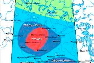
The area runs from Saskatoon to North Battleford and extends north to Waskesiu Lake. Before, the highest-risk area was a smaller zone between Saskatoon and Prince Albert and the Battlefords were not included in the red zone. Now, the red zone extends all the way to North Battleford and north of Prince Albert.
Also identified as a high-risk red zone is an area from Moose Jaw to Indian Head extending south to Weyburn.
Both are described as being in line for a one in 25 year flooding event.
The April forecast announcement was made by minister responsible for the WSA, Ken Cheveldayoff.
In a statement, the minister noted that due to snowfall in March "the areas in the Souris River and Qu'Appelle River basins have been the most affected."
"To help prepare for the runoff, the Water Security Agency has been increasing the outflow of water from Rafferty and Alameda reservoirs as well as holding several meetings with municipalities to address their concerns and inform them of programs available."
The government says there have been a number of meetings held in at-risk regions, with both the Ministry of Government Relations and the WSA providing more than 200 communities with information and advice about what they could do to prevent and react to the flooding.
Cheveldayoff is urging people to "look at the forecast and prepare for flooding."
Patrick Boyle of the Water Security Agency told the Regional Optimist, folks in the Battlefords and region should be prepared for something similar to two years ago. In North Battleford specifically, "what's fresh in everybody's mind is 2011," said Boyle.
That event saw flooding throughout the area including around the North Saskatchewan River.
One reason for the expansion of the high-risk zone is the weather in March. "There's greater amounts than normal of precipitation in some areas," said Boyle.
Another measure is the snow pack. In North Battleford said Boyle, it's "150 to 200 per cent above our water equivalents or snow pack for this time of year. So there's a lot of water in the snow, and that's factored into our forecasts."
To come up with the forecasts, the agency's staff go out to the regions and do on the ground sampling and take satellite data. The forecasts are described as a general indication for the areas, and each pocket or area could change.
The full forecast can be found online at www.wsask.ca. The WSA plans to update the forecast as the spring runoff begins.
Boyle advises those in the Battlefords area who have concerns or questions to contact the WSA regional office in North Battleford. As well, people are being advised to do their own preparations, such as shovelling snow away from the house, keeping drains cleared, and other measures.
"When it does melt, and it will melt, be as prepared as possible," Boyle urges.
.png;w=120;h=80;mode=crop)

