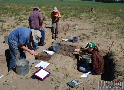
They still have a lot of unanswered questions, but they've come up with some unexpected information in the past year. On April 11, the archeologists investigating the Original Humboldt site southwest of the present city presented the result of their 2011 geophysics work and excavations at the 1885 military camp called Fort Denison on the Original Humboldt land. "We collected a lot of data last year," said Jim Finnegan of Western Heritage Services, the group that is conducting research on Original Humboldt. "Some of it was new. We have lots still to collect."Among the most interesting data to come out of last year's activities came from a geoarcheologist who took samples from the hearth area of the camp - an area where a multitude of animal bones and other burned material has been found on digs in 2010 and 2011. The geoarcheologist discovered, by studying the layers of the hearth and the microstructures in the soil that the hearth had been used on at least five separate occasions, by different people at different periods of time."It was not one event... There were at least five to six events there," Finnegan said. "(The hearth) is not a single, simple feature. It's very complex." First, it was dug in, and used to burn low-heat volume fuels, likely dung and grass, he continued. They speculate it was used by First Nations, due to the fuel. The second period of hearth use, unrelated to the first, shows small burned and unburned bones. It was also clear that the hearth was maintained at this point - actually raked and trampled. Then there was a break in time and in the use of the hearth. In its third period of use, there was less burned bone found, and chemical measurements show fewer phosphates, which are correlated with human activity. This was a lighter and shorter use of the hearth, Finnegan said. The hearth was then used for disposal of some material, and was plowed over. This information put together gives archeologists "a whole different view of the site," said Finnegan. The soil, he continued, tells them things "we can't tell with the naked eye. We really need this... to get the story out."When questioned, Finnegan noted that the reason this hearth area was used so many times was possibly because it was close to the Carlton Trail, and had a bit of shelter. "It was a good spot to be. It makes sense it was used over and over," he said. Just how many years apart the uses were has not been determined. "It could be all within five years," he said.The geoarcheologist is still going through data and is learning new things, almost on a daily basis. "It's such an interesting site," said Finnegan. "It's fun for us as a company." There are many layers to the 80-acre Original Humboldt site. There's the Telegraph Station which was occupied from 1878 to 1882. Then there is the site of the military camp, which was under the command of Lt.-Col. Denison in 1885 - the time of the Northwest Rebellion. The area was homesteaded by the Fahl family in 1903.In the 1980s, the owner of the land, August Fahl and a local RCMP officer named Larry McLeod, started to raise awareness about the significance of the site.Then in 2009, the land was purchased from Joan and Harold Hergott to be held in public trust, and research on the site, including excavation work, began - using funds from the Saskatchewan Heritage Foundation, staff and volunteers from the Humboldt and District Museum and Gallery (HDMG), and specialists from Western Heritage Services.In 2009, their first excavation focused on the Telegraph Station site, noted Jennifer Hoesgen, director of the HDMG.In 2010, the work of Western Heritage Services at the site focused on the Fort Denison area. There, they found most of the skeleton of a horse in what was believed to be the hearth area. In 2011, the site was officially dedicated, and a public access area was created to explain the different parts of the site.They have plans, Hoesgen noted, to do some education and tours of the site, to turn part of it back to natural grasses, and to develop walking trails to the heritage features, along with interpretive signage, and perhaps some structures, "to help people get a sense of the story of Original Humboldt."Fort DenisonWhen they began their work at Fort Denison, archeologists weren't sure what they were going to find, Finnegan told the crowd of about 30 who gathered at the HDMG to hear about their work on April 11. There hasn't been a lot of work done on sites of this type - a temporary military camp - "so it was completely mysterious what we would find," Finnegan noted. For a brief period in 1885, that area was buzzing with soldiers. They put in posts for their horses, a hearth, dug earthworks for fortifications. They didn't alter the landscape very much and took a lot of the materials back with them, so it presents researchers with a challenge. The soldiers arrived in the area in May of 1885, after marching from Fort Qu'Appelle. Under orders of Lt.-Col. Denison, the area was fortified - meaning, the troops dug in, Finnegan said - in order to make the site defendable. The purpose of the camp was to defend the military stores for the troops fighting the Northwest Rebellion, and when the fortification was complete, Denison was pleased that they could easily accomplish that, Finnegan indicated.As General Middleton skirmished with the troops under the command of Louis Riel and Gabriel Dumont at Batoche, more troops - the York and Simcoe Rangers, arrived at Humboldt. That added another 27 officers and 342 men to the site by May 19. Photos of the fort taken at the time, or artists' renderings done by war correspondents, showed a wealth of supplies at the Humboldt site - many boxes and crates."It would be quite a sight on the prairies," said Finnegan. "That's why it was worth defending; they wouldn't want it to fall into the enemy's hands."So there was a huge amount of activity happening at the camp - daily patrols, wagons arriving and leaving all the time - until their orders came to leave Humboldt and return to eastern Canada in early July.Though there were 50 wagons a day going through the area, back to Qu'Appelle, Denison was not allowed to use them, Finnegan noted. "That's why things were left (like empty cans and bullets). They couldn't carry them back.... they left it and marched back, all because they couldn't get wagons," Finnegan said. The investigationIn 2010, archeologists with Western Heritage Services decided to restrict their work to a sandy hill, which was believed to have been part of Fort Denison, due to flooding on other parts of the site. They found, through their topographical work with Ground Penetrating Radar, and the discovery of the horse, a whole bunch of unanswered questions about that part of the site. "We didn't want to leave then," Finnegan said. "We wanted to get some more definitive answers."Their objective for 2011 was to determine the fortified portions of Fort Denison.They focused on what they called "the sandy knoll" to determine whether it was man-made and how big it was, so they did some microtopography. They mapped "Mount Denison" using over 3,400 elevation measurements. But they still need about 3,000 more, they found out over the winter. But their work showed this "really produced a significant new way of looking at the site," Finnegan said.They also measured the ground's magnetic susceptibility, which is very sensitive to human-modified soils.They drilled 314 holes and did readings every five centimetres in depth.That produced "puzzling results" Finnegan said, which they still have to figure out. One thing they do know is that they are seeing correspondence between the soil profiles and other research they have done at the site. "We don't know all the answers. We are still researching and plan to do more."Besides the geoarcheology work, more traditional archeology work also went on at the site over the summer. A trench made in the summer of 2010 was re-dug with the help of volunteers, and a central area of the hearth was excavated, reported archeologist Karmen VanderZwan. Though they excavated a smaller area than in 2010, they still came up with a large volume of artifacts, she said. About 30 centimetres down, they found a row of vertebrae, dark patches of charcoal and burnt bone. Another 10 centimetres down, they uncovered the entire vertebral column of a coyote - they had found the skull in another unit in 2010 - including two shoulder blades and ribs. They also found the skull of a red fox and more sections of vertebrae and skulls.Though the materials around the skeletons were burned, the skeletons themselves were not."That suggests they were dumped on top of burned material," VanderZwan said. "On all kinds of garbage, all in one spot." The area of debris got smaller about 50 cm down, and they reached the bottom of the hearth, and stopped digging at about 70 cm depth."Artifacts we found in 2011 were 99 per cent bones. Not a lot of buckles, nails, bullets, etc," VanderZwan said.However, last fall, another discovery was made when Peggy McKeand of Western Heritage Services came back to the site to do some soil susceptibility testing. Drilling a hole for the testing, they found a cache of four large, rectangular tin cans, some with lids attached, and others without. The cans had very faint writing on them, which is unreadable, but due to their type, VanderZwan was able to date them to the time of Fort Denison. The cans had a "hole in cap" closure that was typically used in canning food between 1823 and 1910. The seams of the can show it to be pre-1888, she continued, which narrows the timeframe further. The tins likely contained corned beef, also known as bully beef, which is what the soldiers ate, according to Denison's writings.There are likely more cans to be found at the site, VanderZwan noted. "The cache is probably in larger amounts than in the test pit," she said.It's one of the areas they want to focus attention on this summer during their dig, as a geophysics map shows a large anomaly in that area. "So it might be something really cool," VanderZwan said. "Did we figure it all out? No," said Finnegan of what they found in 2011. "We collected significant new information... (which) showed us where there are holes in our knowledge.... We found we lost the first skirmish, but we will win the war," he said, likening the archeological dig to a battle. As information is collected, other information from maps and photos begin to make sense, he said.Their goal for 2012 is to definitively map the fortifications - the walls of what was Fort Denison.Once they map out this fort, they will have a map that exists nowhere else in the world. No one drew maps of this fort, he said, which is important to the whole story of 1885. They also plan to open up the can dump, and see if it was a pit for refuse or part of a trench.If it's a pit, Finnegan noted, that will tell them there were storage pits inside the fort, and that there could be more to find. If it's a trench, they will follow it and see what else they can find in there."We're not digging a hole to find more cans," he explained. "That's not what we're interested in. We're interested in why were the cans buried?"The soldiers would not dig a hole to bury the cans, he said, so they need to find out why they were. "One possibility, though it's not likely, is (that the cans were in the) latrine."The latrine is something they hope to find in 2012 as well, using satellite photos from as far back as 1980 to locate places on the site where crops were especially good or especially bad.Latrines, Finnegan noted, are where you can find a lot of things."People dump things there," he said, "things they don't want you to know about them."For instance, he said, in North West Mounted Police privies, they've found a lot of liquor bottles.They also plan to expand their geophysics work, and go a little off the hilltop to the north, where a surveyors map from early in the 20th century marks an old military camp."It's half a quarter - a tiny area," Finnegan said of Original Humboldt. "But it takes a lot of effort to explore."Western Heritage Services has been testing new technology to map out and explore Original Humboldt, which is of major importance to the science of archeology, and "will benefit archeologists for generations to come," Finnegan added.The HDMG is looking for help with this summer's dig. Those who would like to sign up can contact the HDMG.
.png;w=120;h=80;mode=crop)

.png;w=120;h=80;mode=crop)