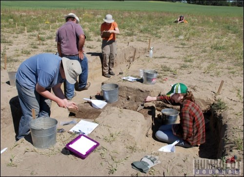
Archeologists were out at the Original Humboldt Site during the week of August 1 to continue work they started in 2010.
A crew of professionals and volunteers were out in the hot sun to make new discoveries at the site.
Work on the site started in 1995, said Jim Finnigan, archeologist from Western Heritage Services.
The crew from Western Heritage Services was commissioned to find the original site of the telegraph station.
They found what they thought was a trench, but did not continue until recently.
"Three years ago, Jennifer (Hoesgen from the Humboldt and District Museum and Gallery) called us back," said Finnigan.
He said she asked them to come back and help discover what else was at the site.
"We really wanted to focus on the hilltop," said Finnigan. "As far as we know, that is where the fort area and stores were."
Last year, at the end of their time at the site, they found the hearth.
"We decided to find out everything about it we could," said Finnigan.
A few of the professionals at the site this year were Peggy McKeand, Finnigan, Krista Gilliand and Karmen VanderZwan.
McKeand, an archeologist with Western Heritage Services, was checking the soil susceptibility of the site.
"I was checking the magnetization of the soil," said McKeand.
In order to check the magnetization, McKeand used a probe. She made a hole in the ground about an inch in diameter and checked the magnetizations every five centimetres, down to 80 centimetres.
"Naturally there is always some magnetic activity but cultural activity increases magnetization," said McKeand.
She explained that when things decay they give off more magnetization than the soil would normally give off.
After checking the magnetization every two metres, the data will be put into a software program that will create a 3D map of the area.
"We're hoping to combine it with the data from ground penetrating radar and gradiometer," said McKeand.
They used a similar technique last year which helped them decide where to dig.
To help create the 3D map, Finnigan was taking elevation measurements every metre to try to create a detailed topographic map.
Soil specialist Gilliand is a new member of the team this year.
"I'm looking at the soil as an artifact," said Gilliand. "Soil is shaped by people and cultural activities."
Gilliand explained that human interactions are shown in the soil, whether they walked on it or dropped items on it to decay.
"I can tell where the soil is natural and where it was manipulated by people," said Gilliand.
"We think we've found the feature where they built up the site."
The hearth and fire make the soil look different than it would naturally, explained Gilliand.
She said she could see at least four episodes of human activity by looking at the layers of the soil.
"The different colours in the soil mean different things," explained Gilliand. "For example, the orange colour shows wetting and drying. (Also) when it is not straight - this indicates walking on the soil."
The last pieces of the puzzle were being put together by archeologist VanderZwan.
VanderZwan and a team of volunteers were working at the area where they found a horse skeleton last year.
"This year we started back at the same place because we ran out of time last year," said VanderZwan.
They were examining the area where the hearth was located. Last year they uncovered three quarters of the hearth. That is were they started this year.
"Once this is finished we will have a good presentation of what the hearth was used for," said VanderZwan.
So far, they have the theory that the hearth was used as a refuse dump, which is indicated by the skeletons of foxes and coyotes, as well as tin cans, glass and buttons.
"Now that they are working on soils, it might help indicate where the hearth was located in the camp," said VanderZwan. "(Gilliand) has brought new ideas to the project and will help us interpret the site to the best we can achieve."
Finnigan hopes once they compile all their results from this year's dig, they will have a better picture of the site and how it was arranged.
"I think by the time this is done we'll have a picture of what this hill was formed for," said Finnigan.


