Pre-planning work for the twinning of Highway 39 between Estevan and Bienfait was released last week.
The Ministry of Highways and Infrastructure hosted an open house at the Estevan Leisure Centre May 22 asking for input from the public on the two options presented last week, which would see two lanes of highway added to the road either directly north or south of the existing highway to create a four-lane, divided Highway 39.
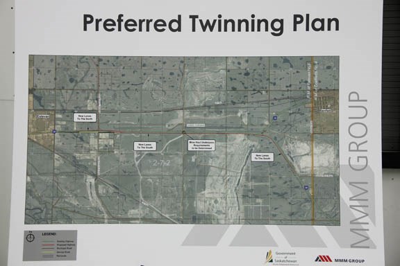
The Ministry unveiled its preferred plan for the new lanes, which would see the expansion run south of the existing highway, linking up with the old highway.
The Highways' preferred plan would see the four lanes near Estevan begin just east of where Souris Valley Paving sits. Under this plan, new lanes would be constructed north of the existing westbound lanes, past the Shand Access Road, avoiding any conflict with existing businesses and homes.
As the highway stretches east of Kramer CAT's property, eastbound traffic would slide over to new highway lanes south of the highway and the new westbound lanes would be linked with the current highway.
The initial twinning, according to the preferred plan outlined last week, would see four lanes extend east of Bienfait, with new lanes running to some point near the Bienfait Mine Road before reverting back to a two-lane highway.
There are plans, however, to run Highway 39 as four lanes from Bienfait to North Portal. This fall, the Ministry will continue to plan for twinning related to that second section of the highway.
There were no plans or timelines suggested for the twinning of Highway 39 and 6 between Estevan and Regina, which has also been slated for the future.
"The government has announced its intention to do the pre-construction work from Estevan to Regina, and it's in the very early stages as well," said Doug Wakabayashi, the Ministry spokesperson, who added they are determining how they are going to scope the work and develop terms of reference for the various consultants who will be involved.
Wakabayashi called the preferred plan of connecting with the old highway a starting point.
"There are options. We have some displays here that show various options that we're looking at, and the alternate location of the new lanes could be one of the options or could be a hybrid of one or more of them," said Wakabayashi.
The displays are available on the Ministry's website for continued public scrutiny.
Engineering consultants from MMM Group were on hand to answer questions regarding the options and a large map was laid on a table so attendees could write specific suggestions onto the exact area of the plan they were referring to.
There are a number of logistical issues the Ministry has to deal with prior to the commencement of construction, including traffic operations, access to the highway, topography, utility constraints, soil conditions, property impacts, environmental impacts and the coal mining operations in the area.
"We're looking for what other constraints there might be. For example, the mine operation, if there are any constraints (with that). It also provides us an opportunity to show some options that we're looking at right now to the public and give area residents an opportunity to provide some feedback as well."
Throughout planning, the ministry must be cognizant of numerous environmental concerns as well as the location of utilities. Most of the land adjacent to the highway is either commercial or industrial land, or part of mining operations.
"Tonight's an important step in the pre-construction process for the future twinning of Highway 39 between Estevan and Bienfait. Specifically what we're doing is a location study, and what that means is we're determining what side of the existing highway we're going to twin on. Part of that process is looking at what land use exists currently on both sides of the highway, how traffic is accessing it, things like that," said Wakabayashi.
"The location study will go on for a little while yet. In addition, once the location study is done, the next phase is called functional planning where we do things like determine what specifically our right-of-way requirements will be, access points to and from the highway, the configuration of intersections. That will be a point where we ask for public input as well," he added.
The plans show an onramp for westbound traffic to transition onto the Estevan heavy-truck bypass, and Wakabayashi said the bypass, which is currently under construction, has some influence on the twinning project.
"It should hook up pretty naturally. The connection to Highway 39 was one of the key considerations in the planning for the bypass."


