In the first two weeks of February, I’ve heard more about the possibility of exporting oil by way of Churchill than I have in several years. The first recent mention I saw was in an announcement that Premier Scott Moe is forming a cabinet committee to look at proposals for export pipelines, including the possibility of investing public money into projects, as a way of reducing the political risk.
Alberta Premier Jason Kenney has been talking about it, too.
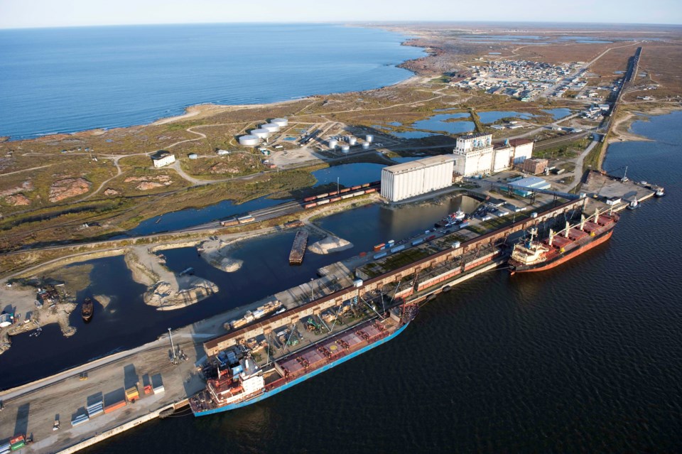
But a Global News story on Feb. 13, quoting Manitoba Premier Brian Pallister talking about Churchill, suddenly made this more real.
The initial concepts of shipping oil by tankers out of Churchill, Manitoba, was to get the oil there by rail.
But in the intervening years, the rail line basically fell apart due to flooding. Its operator, Omnitrax, didn’t want to put any money into it. Only recently has that rail line, under new ownership which includes many local First Nations, gone back into operation. Given the recent propensity for crude-by-rail derailments (on the Canadian Pacific mainline, no less), the idea of using the Hudson Bay Railway, with its ever-wonky track, loses a lot of appeal.
So now the talk is about a pipeline. There’s basically two ways to build a pipeline to Churchill. One would involve an almost straight line east from Fort McMurray to Churchill, with zero roads or rail along the route. It would be primary across the Canadian Shield, one of the toughest environments across which to build, well, anything, including a pipeline. Bring lots of dynamite. My measurements on Google Maps puts such a pipeline at about 1050 kilometres as the crow flies. A substantial portion would be through the Athabasca Basin.
The other alternative would be to connect to the Enbridge Mainline at its Cromer, Manitoba, terminal. It is almost as far as you can get from Churchill and still be within Manitoba, about 1300 kilometres. The first 450 kilometres of that, and possibly the last 70 or so, would be in the soft soil. That last 70, in the Hudson Bay Lowlands, could be a challenge. The rest is shield.
As the crow flies, the distance is almost identical from Fort McMurray, but having to snake around parks in the south, then follow the rail line in the north (the only way to get pipe, material, equipment and men up there), makes up for that additional 250 kilometres.
That is not, by any means, a short pipeline. Nor would I expect it to be a large one. A 16-inch line would give you about 250,000 bpd capacity. A 20 inch would be closer to 500,000 bpd. But there’s no way they’d consider a 36-inch line like Keystone XL, with 830,000 bpd in capacity.
Why?
Because such a pipeline would fill a very large crude carrier (VLCC), i.e. a supertanker, every day, or every second day if it was an ultra large crude carrier, year-round.
That is a lot of ship movements coming into a port that, without building a large fleet of icebreakers, is only ice-free an average of 112.7 days per year. I’m talking more icebreakers than in the entire Canadian fleet, as we speak. Canada’s newest polar icebreaker, which still hasn’t started construction, saw its budget balloon from $720 million in 2008 to $1.3 billion, in 2013.
Alternatively, you could have several ice-capable tankers to shuttle oil in the winter months from Churchill to some transfer point off the island of Newfoundland – perhaps some quiet, deep ice-free bay that would make a good transfer harbour.
That “shuttle run” would be 3,100 kilometres each way from Churchill to the coast of Newfoundland. The total shuttle run, at 6,200 kilometres, is a little under the total distance from Kitimat South Korea, but whose counting?
And if you’re loading a ship a day, or even every third day, you would need a lot of ships in transit in the winter just to keep that sort of volume moving. And remember, you don’t make 15 knots in ice. In 1.8 metres of ice, the best U.S. icebreaker makes three knots. Hudson Bay ice gets to be up to 1.6 metres.
At that speed, doing 135 kilometres a day, it would take a ship 13 days to get from Churchill to ice-free water off of the northern tip of Labrador.
For all these reasons, I can’t fathom anything more than a 16-inch pipeline, or more than 250,000 bpd in exports from Churchill.
What volume of oil, each day, 365 days a year will it take to pay for not only the pipeline, tankage port facilities, ice-capable tankers or icebreakers, AND make an impact on Western Canadian oil prices?
This is, after all, the whole argument for “getting to tidewater.”
Trans Mountain Expansion ballooned in price to $12.6 billion. At 1,150 kilometres, it’s a similar length to either a Fort Mac-Churchill or Cromer-Churchill line. The difference is building in mountains, and the Lower Mainland, versus building in Canadian Shield. The Churchill option is quite literally all downhill, which makes pumping it that much easier. So how much would a Churchill pipeline cost? I have no idea.
The biggest difference is a Cromer-Churchill line would be entirely within the province of Manitoba. That means, as proven by a recent court case involving Coastal GasLink, the Canada Energy Regulator, and its strangling approval process, wouldn’t touch it. That makes it simple.
Cromer to Churchill makes it the only way to go.
And that’s despite the fact the oil would quite literally make a horseshoe path from the top of Alberta to the bottom of Saskatchewan and Manitoba, and back to the top of Manitoba again. Because of the disaster which is the Canada Energy Regulator and its predecessor, the National Energy Board, it makes more sense to do that then build a straight line from Fort Mac to Churchill.
Put that in your pipe and smoke it.
Brian Zinchuk is editor of Pipeline News. He can be reached at [email protected].


