The melt is on in the southeast where spring has apparently sprung. With warm weather throughout last week, the annual spring runoff is well underway across this corner of the province.
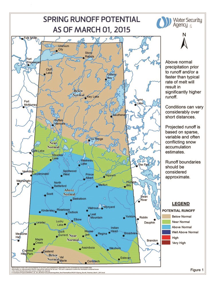
For much of Saskatchewan, including the Estevan area, spring runoff is expected by the Water Security Agency to be normal. Though snow disappeared around Estevan, the runoff season can’t be said to be over, and Monday’s dusting is proof of that.
Patrick Boyle, WSA spokesperson, said the WSA’s forecasts operate based on current observed data and the assumption of normal conditions in the months to come.
“We don’t really know what the weather is going to be. For us with this forecast, we’re looking at a near normal situation throughout the Estevan region, but there is also a central part of the grain belt coming down to just above Estevan that has been put into the above normal category,” said Boyle.
That upgrade was the result of above normal snowfall for the month of February.
“That, combined with some pointed snow surveys in that region and found the snow water equivalent (SWE) was higher, so there’s more water in the snow there,” said Boyle, noting that’s what pushed the runoff forecast to an expected higher than normal. SWE is the depth of water that if left from the melting of seasonal snowpack.
Terminal lakes and wetlands that have no natural outlet to drain will continue to remain high for the foreseeable future and with a normal spring runoff could see some flooding issues. Many of these areas remain at higher than normal levels following several years of high runoff with little to no net evaporation.
Surveys on Feb. 17 and 26 found there is an above normal water equivalent in the snowpack throughout the province’s central grain belt.
Over the course of the winter months the Estevan area has received a typical level of snowfall. Much of the area has seen precipitation, which has been monitored by Agriculture and Agri-Food Canada, between Nov. 1, 2014 and March 2 that is about 85 to 115 per cent of the average precipitation.
According to Environment Canada, the snowpack north and west of Estevan has been observed with a near normal snow-water equivalent. It’s the snowpack east of the city that has been found to have an above normal SWE. The readings show this snowpack has between 120 to 160 per cent of what is considered normal.
Around Estevan, as of March 2, snow on the ground had about 23 mm of SWE equivalent, while to the east, the snowpack included 57 mm, 41 mm and 52 mm of SWE at various points between Estevan and the Manitoba border.
The Estevan area saw a lot of precipitation in February. Between Feb. 1 and March 2, much of the area north and west saw anywhere from 150 to 200 per cent of normal precipitation, while east of the city saw between 115 and 150 per cent of normal.
But by the middle of March, snow accumulation around Estevan was completely gone. Still, upstream of the Souris River, there continues to be a steady melt.
“We’re starting to see some of the melt underway. What we’re looking for now is plus five and then freezing at night,” said Boyle. Cooler nights that dip back below freezing make for an ideal and more controlled melt.
“That would certainly benefit a lot of this to get that slow, gradual melt.”
Boyle cautioned that all of this forecasting is subject to future conditions in roughly the next six weeks. Despite recent fair weather, the southeast isn’t guaranteed to be without snow in the coming weeks.
“We’re cautiously moving ahead here. Things are fairly positive right now,” he said.
Boyle added that spring runoff isn’t the only indicator of water issues. Last year, the runoff went smoothly until a summer rainstorm pelted already saturated ground northeast of Estevan and caused some flooding around Gainsborouh and Moosomin. That flooding left those areas saturated once again.
“Going into the fall, we were fairly saturated from that event. It was a very significant rainfall event,” he said.
“Those normal creeks and streams that would run dry, they were still running into freeze up. Normally, they would be dry going into freeze up … so some of that water could still be around. You look at some of the basins where there aren’t many natural outlets for drainage then you’ll have some of that water there, certainly,” said Boyle.
For any real trouble, he said, the snowpack in the southeast would have to increase significantly, and that’s not something the WSA is expecting.


