A beer bottle. A wine bottle. A wick guide for an oil lamp. A marmalade tin.
These are just a few of the items a team of archeologists and volunteers dug up at the Original Humboldt site over two weeks in July.
There was a hum of activity on the Fort Denison portion of the site, located southwest of Humboldt between July 9-20.
Not only was there an archeological dig happening where Canadian troops were stationed during the Northwest Resistance in 1885, other geophysical work to map the site was being carried out.
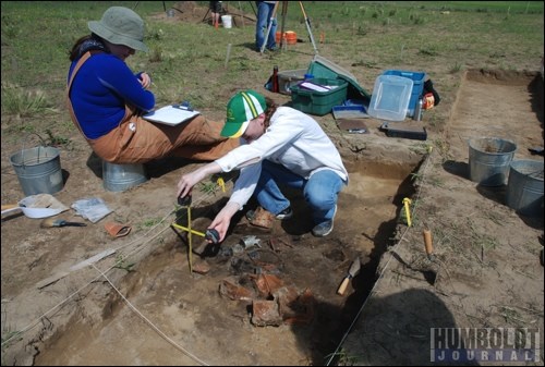
During the dig, two separate sites were excavated.
The first was where a cache of cans had been found last fall, when geophysical mapping had been going on at the site. A small hole dug at that time resulted in the uncovering of a variety of cans which likely held corned beef. They were dated to around 1885, and likely were part of the soldiers' rations.
This July, that site was opened up further. Items found included more cans, including a large square one that looked like a tray, a Budweiser bottle, a wine bottle and an orange marmalade tin.
Further down, they also uncovered bits of bone.
Once the team of volunteer diggers and archeologists from Western Heritage Services had deemed there was nothing left there, they turned their attention to another possible cache, located through a magnetometer survey.
There, they found the wick guide for an oil lamp, more cans, bottles, wire and a bit of black fabric.
"Both were just refuse pits," reported archeologist Karmen VanderZwan.
In other words, these are pits where the soldiers stationed at the site to guard stores for the advancing troops threw their garbage.
That's good news for the excavation, as garbage pits are filled with a wealth of information, VanderZwan indicated.
And these are just two of several anomalies showing in the geophysical surveys of the site. There will be more refuse pits to dig out in the years to come.
While the dig at the second refuse pit was going on, geoarcheologist Krista Gillilana was at the site of the first, recording the layers of soil.
Mapping this stratigraphy, she explained, is done in order to understand what the landscape was like when people arrived out here. It's also done to undestand the sequences of activity at the site.
Last year, mapping the hearth area of the site - located between the two dig areas this year - the focus of digs at the site for two summers, revealed that there was more than one activity period for the hearth - at least three or four - which was new information for researchers.
This year, what the layers of soil were telling Gillilana was that the entire area was under water at some point.
She pointed out a banded layer of clay, which would have settled on the bottom of a lake or a prairie pothole, as Gillilana described it.
"It was standing water - no disturbances, not a lot of flow. That allowed the clay to settle (at the bottom)," she said.
As the dig is occurring on top of a sandy hill, that "demonstrates there was a lot of water covering the area at some point in the past, quite a long time before Fort Denison was established," she said. "It shows the environment and topography of the area were very different in the past."
In order to preserve the layers of soil and the information they share, Gillilana was going to do a latex peel of part of the dig site. When complete, this snapshot of the stratigraphy will be put up for display, with the help of some plexiglass.
"It will be the first piece of Original Humboldt art," said Jennifer Hoesgen, director of the Humboldt and District Museum and Gallery (HDMG), the body that funded the dig.
More mapping of the area was also done over those two weeks, using two different methods.
More magnetometer readings were taken, and a new method of data collection was also used.
They took resistivity measurements, explained archeologist Peggy McKeand, while her counterpart, Jim Finnigan, was involved in doing the work.
This method measures how resistant soil is to passing an electrical current through it.
After a current goes through part of the soil, the machine gives a measurement, she said, and they can then use those measurements to plot areas of soil disturbance throughout the area.
From the data collected, it appears as though there is an area of soil disturbance arcing around the whole hill, which may be the trench the soldiers dug when they got there, to help protect the stores they were guarding.
These readings are just another way of telling what's happening below the surface of the soil, and when put together with other readings collected by other methods, it gives them a better picture of what's there, McKeand noted.
"It's still always challenging to understand the site 127 years later. The more information we have, the better we can understand the depth of the site, and the extent of it," Hoesgen said.
The dig was an unqualified success, according to Hoesgen.
"It's been a good two weeks," she noted at the dig site.
Having the public take part in the excavation was exciting for the HDMG, she added.
Volunteers as young as 12 and as old as 80-plus came out to help at the dig and learn a bit about archeology and history at the same time.
"To be able to do public archeology, to hear the enthusiasm of a 12-year-old, their excitement as a trowel hits a piece of metal" is just a great way to spend some warm days outside, she said.
The final analysis about what was found during this year's work at the site won't be announced for some months, as the archeologists continue their work in a lab setting.
"Stay tuned for what we find out," Hoesgen said.


