The peak seems to have passed when it comes to runoff heading into Waldsea, Deadmoose and Houghton lakes north of Humboldt.
The levels of both Deadmoose and Houghton lakes are coming down, while Waldsea lake is rising, reported Dwayne Rowlett of the Saskatchewan Watershed Authority on April 25.
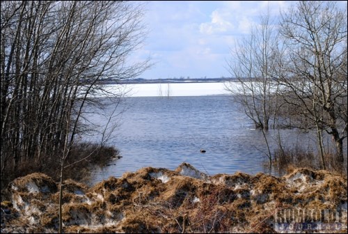
Though he did not have recent measurements for Waldsea Lake, "it has come up substantially," he noted- by feet, not inches, he added.
The water has not only breached the berm at Waldsea, it is across the road that runs north and south just east of the lake.
As of April 19, both Deadmoose and Houghton were down 11 inches from their high point this spring, he added, so their plan to flood Waldsea in order to save land around Deadmoose and Houghton is working.
"It is doing what we planned it to do," he agreed.
The peak has passed on Deadmoose and Houghton, he added.
"We're not having water levels going higher this spring," he said.
Had they not flooded Waldsea Lake, and Deadmoose and Houghton had gone up two or three feet, it "would have been not good," Rowlett said.
The flow of water into Waldsea Lake is slowing now, and will continue to slow as it fills up, he added.
"It will equalize at some point and we will have minimal flows through there," he said.
Flows had been causing Waldsea to rise as much as 10 inches per day.
"That will slow down as we get nearer and nearer to the top."
Grid 777, which runs east-west north of Houghton Lake, is still flooded at one point where the road is closed. Ice still covered the water there last week, and Rowlett has said he has not heard of water moving through there yet. They do plan to build up the road later in the year, he noted, and will not be moving water to Lenore Lake at that point.
"We could do it, but on a practical level, it wouldn't have any influence," he said, as there would not be enough water going through to make a difference.
At the northern end of Lenore Lake, the Prairie Grains road, which goes through the northwest corner of the lake, is acting as a dam right now. The RM has closed the road to traffic and has cut it to allow water to flow through to Frog Lake and Middle Lake.
Elsewhere in the region, water is still sitting in many fields, and causing issues with roads, both gravel and highways, in the area.
Around Watson, Iron Spring Creek is flowing heavily and causing issues for the town. On April 24, was flowing at its third-highest rate since 1921.
Quills Creek was also at 34.5 m3/s is at a record level.
Both creeks empty into the Quill Lakes, near Wynyard. The Quill Lakes are rising and expected to reach elevations not seen since the 1920s over the next few weeks.
Water is covering Hwy. 16 near Lanigan, causing delays in traffic moving through that location.
Water has also led to a number of closed roads in local RMs, including north of St. Gregor, north of Englefeld and south of Fulda.


