Put the tools away and stop hoarding supplies for ark construction, the spring runoff forecast does not spell doom and gloom.
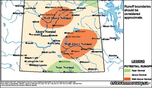
After a dry second half to 2012, the winter precipitation is pushing the expected spring runoff rates in much of Saskatchewan to be above normal. That probably isn't welcome news to many residents in the southeast who remember the spring flooding in 2011; however, the runoff forecast assembled by the Water Security Agency (WSA) with information as recent as Feb. 1 isn't suggesting anybody should panic yet.
In the last half of 2012, there was below normal rainfall for most of the agricultural areas in the province. That could play a significant role come spring.
"That left us with relatively dry conditions going into the winter season," said Patrick Boyle of the WSA.
While the spring runoff potential in the southeast is above normal, the area from Moose Jaw to Wynyard and Yorkton could see runoff that is well above normal.
If the region experiences average precipitation over the next couple of months, the current excess will pose less of a problem.
Boyle noted that since 2010, a good chunk of provincial funding - $25 million - has gone to flood mitigation efforts. That investment has allowed for the installation of new berms and ditches.
"We're in a different spot from 2010 to 2011 because there is work that has already been done," said Boyle. "People say, 'what about 2011?' Compared to 2011 it is a different situation. In 2011, the snowmelt was handled without any issues. The flooding from that year was mostly due to well above normal spring and summer rains. Because this year we went into that winter season with a lot those sloughs relatively dry, it's a different situation. The next few months will give us a better picture of that runoff."
The biggest thing the WSA is monitoring is the snow-water equivalent.
"We're 150 to 200 per cent above normal for snow-water equivalent," noted Boyle. "That represents how much water would be created if all the snow on the ground melted."
The snow-water equivalent is measured by satellite, though the WSA also took 38 manual snow samples from across the province. The February forecast also includes data of accumulated snowfall from weather stations in Saskatchewan.
"It starts to give us the picture of what spring runoff could look like," said Boyle. "Forecasting is a difficult job because we don't know how much additional snow is going to fall or how quickly it's going to melt."
There are a number of factors that will impact how water runoff will progress once the weather turns warmer. If there are days of high heat and quick melting, that will affect the runoff rate, as will how much rainfall occurs once the snow begins to melt.
"Those factors can have a major effect on the runoff," added Boyle.
Those are factors they can account for now by looking at previous averages, but there is still no way to predict how it will unfold in the spring.
The report said with average precipitation in the future, the amount of present excess snow becomes relatively less significant.
"It all depends on what the next few months hold for us, really," said Boyle. "We'll have another forecast in March that should give us a better idea and in more detail, about what the runoff will look like."
The dry fall means the southeast will be more capable of handling the elevated snowfall this winter. One figure in the report showed that much of southern Saskatchewan experienced only 40 per cent or less of the average fall precipitation, while around Estevan it was between 40 and 85 per cent of typical rainfall. From here, there is no way of knowing what's in store in terms of the rate of snowmelt or spring rainfall.
The other factor that has some play in the Prairie's circumstance is the mountain snowpack.
The WSA also monitors the headwaters in the North and South Saskatchewan Rivers, and the snow accumulation in the Rocky Mountains, which typically reach their peak in late April to early May.
The next spring runoff forecast will be released in early March.


