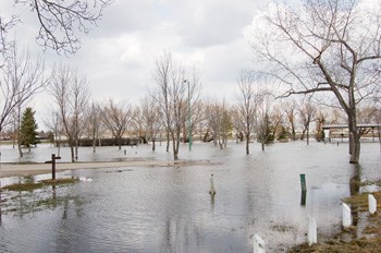
Runoff is well advanced across most parts of southern Saskatchewan and flows have passed their peaks and are receding across much of the area, according to the Saskatchewan Watershed Authority. Exceptions are in the Missouri Watershed south of Cypress Hills, where runoff is still in an early stage, the Qu'Appelle Lakes, Lenore Lake and the Quill Lakes, where levels are still rising, and the upper parts of the Assiniboine, Souris and Red Deer watersheds where snow remains and flows are increasing.
High flows are occurring in the headwaters of the Souris River. Flow of the Souris River near Bechard has dropped to 43 cubic metres per second (m3/s) on April 25 from 72 m3/s on April 24.
Flows out of the Yellow Grass Marsh continue to increase, up to 78.5 m3/s on April 25 from 76 m3/s on April 24, the highest ever recorded. The previous record flow was 52 m3/s in 1976.
Flows through Weyburn are slowly increasing and were 65 m3/s at the time of printing.
Peak flows in Weyburn were expected early this week. Flows from the lower portion of the basin have already passed through the city and the next peak is not expected to cause problems.
The outflow from Boundary Reservoir was stopped on April 25.
The release from Rafferty of 20 m3/s was increased on the 25th to 40 m3/s. A release of 20 m3/s was initiated from Alameda Reservoir on May 25 or 26.
The levels of Rafferty and Alameda reservoirs continue to rise.


