There's more than fish and lots involved.
That is the message farmers from the St. Brieux area want people to know about the closure of the culvert under Grid 777.
In the last three to four years, brothers Louis and Fred Fau, who farm together, have lost four quarters of land to the rising waters of St. Brieux Lake and Lenore Lake.
The Faus own and rent land on the east side of St. Brieux Lake that used to be a mile from the water's edge. This year, the water has risen so much due to rain and drainage from the east that they can't even run cows on the land.
"We've gone from pasturing 50 to 60 cow-calf pairs on the land to zero," said Louis. "And our neighbours have had to do that, too."
The land they've lost is both pasture and crop land. Even some of the land they planted last year to rye is under water now and the rye is being drowned out. It has also suffered washouts in several places from the spring rains.
According to Louis, they've received 14 or 15 inches of rain this spring since the snow has melted.
The Faus are happy that the culvert under Grid 777 has been closed, since the land north of the culvert can't take any more water.
"I feel for those guys," Louis said of the farmers around Houghton and Deadmoose lakes, but they"re in the same boat. "Any water from the south will only compound the problem."
The Faus feel the problem has been a long-time in the making and won't be solved over night.
While the farmers south of the culvert have water flowing from Parker Slough through man-made channels as a problem, the farmers north of the culvert face the same problems with drainage from Range (or Ranch Slough) east of St. Brieux. That slough accumulates the drainage from as far away as the Annaheim, St. James, and Spalding areas, they noted. And it flows through a man-made ditch built about 25 years ago.
Ranch Slough is about six miles east of Hwy. 368 and the ditch, called Boggy Creek, runs into the lake about 11 miles south of St. Brieux. There are control gates on the creek, near the slough, Louis said. The gates were closed for a while this spring, but the roads to the gates are now impassable and the brothers are unsure if they are open or closed.
On June 4, the culverts under the Daylesford grid, which is being used as an alternate route for Hwy. 368, were flowing about half full. Earlier this year, the water was almost running over the road, Louis said.
"This is a big man-made problem, and it's not going to go away by itself," Fred said. "The problem started in the early 1900s when CN needed water for their steamers and Humboldt needed water."
In the past, Lenore Lake and St. Brieux Lake only joined in the spring when the runoff was high. The two have been permanently joined now for a few years, Louis said. The channel is now about half a mile wide, he estimated. Boats use it to go back and forth between the lakes as they fish, Louis noted.
The trip to the Faus' land that is under water is a rough ride, accomplished only by four-wheel drive half ton and the use of a quad.
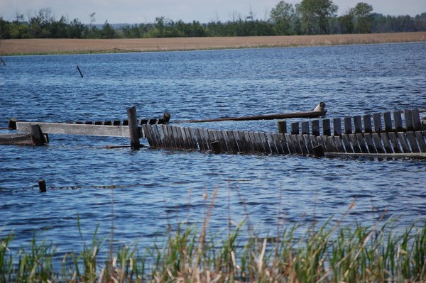
A corral on the land, where only a few years ago they ran cattle is now barely visible above the water. They've also lost fencing to ice and water.
"In 2001-2002, we had to haul water for the livestock on this land," said Fred. "This was bone dry. We've never seen water like this."
The Faus' father moved to the property currently threatened by flooding in 1947. After suffering a flood in 1955, when the water broke through the train tracks to the east, the family moved to their current homestead, just south of St. Brieux along Hwy. 368.
According to the Faus, thousands of acres around the lake - on both sides - have been flooded out this year. One farmer they know on the south end of Lenore Lake has lost seven quarters of land to the rising water. They estimate that the water on their land is about 10 to 12 inches above the high water mark from last year.
"This land is ruined for our lifetime," Louis stated.
The brothers applied to the Provincial Disaster Assistance Program (PDAP) last year and did receive some money for fencing and washouts on crops, but it wasn't very much, they said. They also got a break on their Crown lease for two and a half quarters.
David Nieman is another farmer affected by the rising water. Nieman has land on the east side of Lenore Lake. While he's only lost about 30 acres to the high water, he knows farmers who have lost much more.
"There's thousands of acres of land being lost," he said. "There's acres and acres of bush and farmland under water."
Nieman blames the flooding on the illegal drainage of land surrounding the lakes and says no one wants to do anything about that.
"It's going to destroy everything," he said.
High water levels have been a problem since the 1950s, Nieman said, but as soon as it dries up for a couple of years, everyone forgets about the problem.
He's been farming since the 1950s and 1960s and this is the highest the lake has every been.
"It's just been getting worse with every rain," he said.
Nieman is also concerned about the saline water from Deadmoose and Houghton.
"It would be different if it was fresh (water), but the lake (Lenore Lake) is already on the saline side, so when it floods and recedes, it leaves salt on the land, ruining the land," Nieman said. "We are an experiment. They don't know if it will ruin the land, but they are willing to try it."
According to Nieman, some farmers are trying to seed land around the lake by plane.
"It's a desperate attempt to get some seed in the ground," he said.
Nieman is also involved with the Lake Lenore Lions, who have spent thousands of dollars over the years to create a campsite and picnic area on the south end of Lenore Lake.
The road to the area is under water, as is the camping area, the picnic site, and the beach, he said. The shelter for campers, which is about 10 feet high, is almost completely under water, as are the bathrooms and change rooms.
From the road near the boat launch close to the site, all that's visible is the roof of the shelter.
The campground started to flood in 2006 and 2007, Nieman said. by Pat Peckover
Journal staff writer
There's more than fish and lots involved.
That is the message farmers from the St. Brieux area want people to know about the closure of the culvert under Grid 777.
In the last three to four years, brothers Louis and Fred Fau, who farm together, have lost four quarters of land to the rising waters of St. Brieux Lake and Lenore Lake.
The Faus own and rent land on the east side of St. Brieux Lake that used to be a mile from the water's edge. This year, the water has risen so much due to rain and drainage from the east that they can't even run cows on the land.
"We've gone from pasturing 50 to 60 cow-calf pairs on the land to zero," said Louis. "And our neighbours have had to do that, too."
The land they've lost is both pasture and crop land. Even some of the land they planted last year to rye is under water now and the rye is being drowned out. It has also suffered washouts in several places from the spring rains.
According to Louis, they"ve received 14 or 15 inches of rain this spring since the snow has melted.
The Faus are happy that the culvert under Grid 777 has been closed, since the land north of the culvert can"t take any more water.
"I feel for those guys," Louis said of the farmers around Houghton and Deadmoose lakes, but they"re in the same boat. "Any water from the south will only compound the problem."
The Faus feel the problem has been a long-time in the making and won"t be solved over night.
While the farmers south of the culvert have water flowing from Parker Slough through man-made channels as a problem, the farmers north of the culvert face the same problems with drainage from Range (or Ranch Slough) east of St. Brieux. That slough accumulates the drainage from as far away as the Annaheim, St. James, and Spalding areas, they noted. And it flows through a man-made ditch built about 25 years ago.
Ranch Slough is about six miles east of Hwy. 368 and the ditch, called Boggy Creek, runs into the lake about 11 miles south of St. Brieux. There are control gates on the creek, near the slough, Louis said. The gates were closed for a while this spring, but the roads to the gates are now impassable and the brothers are unsure if they are open or closed.
On June 4, the culverts under the Daylesford grid, which is being used as an alternate route for Hwy. 368, were flowing about half full. Earlier this year, the water was almost running over the road, Louis said.
"This is a big man-made problem, and it"s not going to go away by itself," Fred said. "The problem started in the early 1900s when CN needed water for their steamers and Humboldt needed water."
In the past, Lenore Lake and St. Brieux Lake only joined in the spring when the runoff was high. The two have been permanently joined now for a few years, Louis said. The channel is now about half a mile wide, he estimated. Boats use it to go back and forth between the lakes as they fish, Louis noted.
The trip to the Faus" land that is under water is a rough ride, accomplished only by four-wheel drive half ton and the use of a quad.
A corral on the land, where only a few years ago they ran cattle is now barely visible above the water. They"ve also lost fencing to ice and water.
"In 2001-2002, we had to haul water for the livestock on this land," said Fred. "This was bone dry. We"ve never seen water like this."
The Faus" father moved to the property currently threatened by flooding in 1947. After suffering a flood in 1955, when the water broke through the train tracks to the east, the family moved to their current homestead, just south of St. Brieux along Hwy. 368.
According to the Faus, thousands of acres around the lake " on both sides " have been flooded out this year. One farmer they know on the south end of Lenore Lake has lost seven quarters of land to the rising water. They estimate that the water on their land is about 10 to 12 inches above the high water mark from last year.
"This land is ruined for our lifetime," Louis stated.
The brothers applied to the Provincial Disaster Assistance Program (PDAP) last year and did receive some money for fencing and washouts on crops, but it wasn"t very much, they said. They also got a break on their Crown lease for two and a half quarters.
David Nieman is another farmer affected by the rising water. Nieman has land on the east side of Lenore Lake. While he"s only lost about 30 acres to the high water, he knows farmers who have lost much more.
"There"s thousands of acres of land being lost," he said. "There"s acres and acres of bush and farmland under water."
Nieman blames the flooding on the illegal drainage of land surrounding the lakes and says no one wants to do anything about that.
"It"s going to destroy everything," he said.
High water levels have been a problem since the 1950s, Nieman said, but as soon as it dries up for a couple of years, everyone forgets about the problem.
He"s been farming since the 1950s and 1960s and this is the highest the lake has every been.
"It"s just been getting worse with every rain," he said.
Nieman is also concerned about the saline water from Deadmoose and Houghton.
"It would be different if it was fresh (water), but the lake (Lenore Lake) is already on the saline side, so when it floods and recedes, it leaves salt on the land, ruining the land," Nieman said. "We are an experiment. They don"t know if it will ruin the land, but they are willing to try it."
According to Nieman, some farmers are trying to seed land around the lake by plane.
"It"s a desperate attempt to get some seed in the ground," he said.
Nieman is also involved with the Lake Lenore Lions, who have spent thousands of dollars over the years to create a campsite and picnic area on the south end of Lenore Lake.
The road to the area is under water, as is the camping area, the picnic site, and the beach, he said. The shelter for campers, which is about 10 feet high, is almost completely under water, as are the bathrooms and change rooms.
From the road near the boat launch close to the site, all that"s visible is the roof of the shelter.
The campground started to flood in 2006 and 2007, Nieman said.


