There is concern about the future of Middle Lake, a body of water in the Lenore Lake Basin about 60 kilometres north-east of Humboldt.
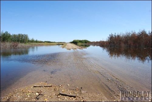
At present, grid road 773 has been closed to traffic since mid-February, after water from the lake flooded the road.
Middle Lake is one of the smaller of the chain of lakes in the Rural Municipality of Three Lakes.
"The lake has come up a long way," said Tim Schmidt, the RM's administrator. "It has flooded quite a bit of land since the spring."
The Lenore Lake Basin is a closed basin of mainly saline lakes with no natural outlets.
This means that the water from one lake runs into the next, working its way from the southern tip of the basin to the northern end. The larger Lake Lenore runs into the much smaller Frog Lake, then into Middle Lake, the second to last body of water in the chain, before eventually reaching the considerably larger Basin Lake.
Right now, even though Middle Lake continues to swell, Dwayne Rowlett, manager of Saskatchewan Watershed Authority's Northern Region Service, believes the lake is not at its full capacity yet.
Rowlett said there was nothing the provincial organization could do about Middle Lake's drainage problem and the consequent high water level.
Allen Baumann, the RM's reeve, sees the current problem as one that dates back to the 1960s, when a two-phase project was enacted to change the flow of water from Lake Lenore.
"There seems to have been a moratorium on the work that was scheduled to take place," Baumann said. "Now there is no more drainage."
"Phase I of the project was to channel water from the lands east of Lake Lenore by installing Conservation and Development ditches, is what I've been led to believe," Baumann explained, "and phase II was to have an outlet into the Goose Hunting Creek to have this water drain off into the river system. Phase II has never materialized, so the water remains stagnant."
Middle Lake and the other bodies of water in the Lake Lenore Basin are one example of changing landscapes because of rising water levels in the province.
Such flooding affects areas in different ways, from the loss of farmable acreage to the balance of the ecosystem to the heavy expense incurred for road work to repair the damage incurred.
In this area at least, problems such as these have been going on for over a century.
"You go up to where Hwy. 20 crosses St. Bernard's road," Baumann said, "there is water on both sides of the road that has been there since the early 1900s. In the early 1900s there was no road there because the level of water was too high and they couldn't build a road."
Baumann said he senses some opposition from people at the Saskatchewan Watershed Authority in controlling the direction that water flows from Lake Lenore.
"They don't want the water going east," the reeve said, "but when Basin Lake is full, where is it going to go?"


