They are not pushing the panic button quite yet but March's heavy snowfalls have increased concerns about the potential of a flood in Southeast Saskatchewan.
The provincial Water Security Agency released its spring runoff forecast for April on Monday morning. In the report, the agency said the estimated runoff volumes for the Souris River Basin are now one-and-a-half to two times higher than those forecasted in March.
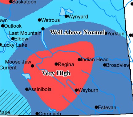
The report added that Estevan, and much of the southeast, is now expected to receive well above normal runoff.
"Over the month of March we had two substantial snowfalls - one in early March and one in the middle of March - and that has increased the snowpack and as a result it has increased our spring runoff potential," said Ken Cheveldayoff, the minister responsible for the Saskatchewan Water Security Agency in an interview Monday afternoon.
"We've expanded the very high (runoff) area in southern Saskatchewan. It now extends from west of Moose Jaw to east of Indian Head and down to Weyburn and over to Coronach and Assiniboia. Estevan is still in the well above normal category."
With concerns arising about the potential of flooding along the Souris River, Cheveldayoff said the WSA has been closely monitoring the local reservoirs. He noted that Rafferty reservoir is actually below the levels set out in the international operating agreement leaving them with a significant amount of flood storage.
"Water has been flowing out of Rafferty since November and we just increased the flow again to 40 cubic metres per second from Rafferty, 20 from Alameda and (10) cubic metres per second from Boundary, so we've got in the neighborhood 70 cubic metres per second flowing down the Souris right now," Cheveldayoff said.
"They are erring on the side of caution for sure, but we feel we are in a good place and we are just continuing to monitor it."
As of April 5, Rafferty was sitting at an elevation of 548.71m and was expected to drop to 548.3m before the start of runoff. Based on the estimates of natural inflows and diversions from Boundary reservoir, Rafferty is expected to peak at 552m this spring and then return to its full supply level of 550.5m in early June.
The situation at Boundary has also changed thanks to the March snowfalls, which impacted the Long Creek basin and increased the amount of runoff expected to flow into the reservoir.
It's anticipated that inflows will now exceed the capacity of the dam and also the diversion channel to Rafferty, which will necessitate a release from Boundary estimated to be in the 60 to 80 m3/s range. The report warned that a rapid melt would generate a higher peak flow and in turn a higher release from the dam.
The anticipated flows are expected to cause some "out of channel flooding downstream of Boundary Dam as well as along the Souris River upstream of the confluence with Long Creek. This would result in inundation of some low lying areas."
Cheveldayoff said although the WSA has completed its forecasts and is ready for the anticipated runoff, he cautioned that there are intangibles beyond their control such as more precipitation and the rate of runoff which, of course, will be dictated by the temperature.
He said the ideal weather over the next couple of weeks would be highs of 10 degrees throughout the day and lows of -5 during the evening. Their biggest fear is receiving a blast of warm weather that would lead to high peak flows into the local reservoirs and force them to increase their releases into the Souris.
"It would melt during the day and freeze overnight and that is the type of weather we would like to see but we don't see that forecast for at least 10 days from now," Cheveldayoff, said.
To prepare the public for the possibility of a flood, the agency will be holding meetings in applicable areas over the next couple of weeks. The first of these meetings was held Thursday in Estevan at the Super 8 Motel. Officials from the WSA and the Emergency Management and Fire Safety office were in attendance to answer questions from the public.


