Although some areas of the province have already begun to prepare for spring flooding, it looks as though the southeast will avoid a repeat of the devastation that hit the region in 2011.
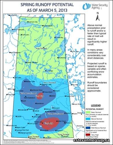
The Saskatchewan Water Management Agency released its March runoff report Monday during a press conference in Regina. The report projects there will be above normal runoff in the Souris River Basin, but because of a dry fall, the chances of a flood such as the one that wreaked havoc in the area in 2011 are minimal.
John Fahlman, the director of hydrology and ground water services for the SWA, said they are expecting a less than one in 10 snowmelt volume in the basin, which means it is a non-flood operation year.
"We had a lot more water volume down there in 2011 than we did this year," he said.
The report noted that winter precipitation ranges from well above normal in the northern portion of the basin to near normal along the border.
As of March 1 Boundary Dam was at an elevation of 559.6 metres which is 1.2m below its full supply level. Based on the current conditions, it's expected that Boundary will refill, with any excess inflows to be diverted to Rafferty through the diversion channel.
Rafferty was sitting at an elevation of 549.45m as of March 1, which is slightly below the full supply level of 550.5m. The WSA is expected to draw Rafferty down to 549.3m prior to spring runoff which they say will provide downstream flood protection while ensuring a 90 per cent chance of refilling based on the current projections. Throughout the spring, water levels are expected to rise 1.5m, which will place the reservoir .5m over the full supply level.
Asked about how this year might compare with the lead up to the 2011 floods, Fahlman said there are a number of differences.
"It was drier in the fall of 2012 than it was in the fall of 2010 so leading up to this winter it was quite a bit drier," he said. "In 2011, not only was it wet but all the depressional storage was filled- the sloughs were all full, a lot of the rivers were running all winter and we didn't see that to the same extent this year so that tells us that the land surface isn't as primed for a high runoff as it was in 2011."
Fahlman added that the WSA has been releasing water throughout the winter and any changes would be made in conjunction with officials in the U.S.
"We have a very formal operating plan for Rafferty and Alameda reservoirs in the southeast. We also work co-operatively with the International Joint Commission so we have a forecasting liaison committee with the United States and ourselves and there is a very formal process as to how much water you release."
As for any potential increases in the amount of water being released from the reservoirs to create additional storage in the event of heavy rains in the spring, Fahlman said there is a delicate balancing act they have to be wary of.
"The dams were designed to provide one in 100 year spring flood protection for downstream interests and they did that. There was a big snowfall that year and that big snowfall filled the dams up very high because that is what they are designed to do.
"The thing that happened in 2011 was after you release the water and get the reservoirs down, it kept raining and raining and that is beyond the design of that system. We could draw the reservoirs down a lot more to try and provide some more downstream flood protection, but that imposes a lot of risk on our water supply and that is a very important water supply there. If you draw it right down and it doesn't fill up again and you go into a drought year, you have some real water supply issues. (Rafferty) will be slightly above its full level but nowhere near its maximum level for flood and that extra storage will buffer a lot of rain."
Although the forecast for the southeast is relatively positive, the same cannot be said for other areas of Saskatchewan. The majority of agricultural areas are expected to get above average runoff while areas such as Regina, Yorkton, Melville, Moose Jaw, Saskatoon and North Battleford could have a very high runoff.
WSA Minister Ken Cheveldayoff said the province has already been in contact with those communities and surrounding RMs to begin planning for any possible floods.
"Overall we are much better prepared than we were two years ago in the event that flooding does occur in certain areas. There were many lessons learned from the 2011 flood by our government officials and our partner municipalities," said Cheveldayoff who added the province will be creating a smartphone app as part of the communications strategy to keep the public informed.
An updated forecast will be provided to the public in April.


.png;w=120;h=80;mode=crop)